Quantcast
Channel: Craig Miller – KQED Science
Viewing all 77 articles
Browse latest View live

At 98, Legendary Science Writer David Perlman Takes ‘Early Retirement’

$
0
0

No one thought David Perlman would ever leave his post at the San Francisco Chronicle. Or at least, that’s what we hoped. But this week word filtered out of the newsroom that Perlman had decided that 60 years or so was enough. The Chronicle says he plans to retire in early August, “around his 99th birthday.”

KQED produced this profile of the ultra-marathon writer in 2014, when he was a mere pup of 95.

The long view is in short supply these days and the media is often found wanting in that respect. But there’s no shortage of historical perspective from one Bay Area journalist. The San Francisco Chronicle’s science editor has been on the job for more than a half-century.

Last month, David Perlman turned 95. We’ll do the math for you. That means Perlman was born in 1918, right at the tail end of a world war — the first one. Perlman says today, young people have trouble enough envisioning the second one.

“When I say World War II, ‘When was that?’ That’s the kind of reaction I get.” He laughs ironically. “It’s sad because it just means that nobody’s teaching history properly.”

There was no mistaking Perlman's work space, piled high with research.
There was no mistaking Perlman’s work space, piled high with research. (Craig Miller/KQED)

First-Hand History

Perlman got some of his own history lessons first-hand. The New York native was a copy boy at the Chronicle when reports came in of an attack on Pearl Harbor. But he admits that his early inspiration to be a journalist came from a screwball comedy: a play about fast-talking, hard-nosed newspaper reporters called The Front Page. The 1931 film adaptation was loaded with rapid-fire lines like, “Hey, listen you crazy baboon, get a pencil and paper and take this down because it’s important!” Perlman can’t quote the film but he can still quote the playwright’s description of this odd breed.
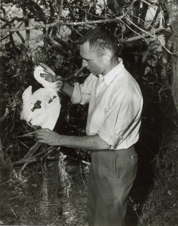
Perlman in the field in 1955. (Art Frisch/San Francisco Chronicle)

“He called them, ‘seedy, catatonic Paul Reveres, full of strange oaths and a touch of childhood.’ I wanted to be like that,” Perlman recalls. “And as a matter of fact, I got to be like that. I think I got more than a touch of childhood.”

Perlman’s always retained a childlike wonder, covering the frontiers of science through five decades.

“Human evolution, let’s say — that’s a great topic,” Perlman offered, recalling the 1974 discovery of “Lucy,” the skeletal remains of a female hominid from more than three million years ago. Perlman seems to have mastered the art of evolution himself, deftly negotiating the long path from manual typewriters to Twitter. (Yes, he does on occasion, tweet from @daveperlman.)

The Final Frontier

Space is clearly one of his passions. “The universe and planets and stars and galaxies, and all the nature of the universe into which we are born.” It was space that launched Perlman’s career as a science writer, in the late 1950s. Hobbled by a skiing mishap, he found himself surprisingly engrossed in a book by British astronomer Sir Fred Hoyle, “The Nature of the Universe.”

“And I got kind of curious about what-all astronomers do — what’s all that about?” he wondered. That led him to Lick Observatory, outside San Jose, and the first of his own science writing, an article on the birth of stars.

“We didn’t have a science writer at the time, so I got to be one,” Perlman said, matter-of-factly. “And it’s been a learning experience for me ever since.”
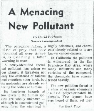
Perlman had already been covering science for a decade when he filed this 1969 piece about the newly-discovered family of toxic chemicals: PCBs. (San Francisco Chronicle)
Perlman had already been covering science for a decade when he filed this 1969 piece about an emerging family of toxic chemicals: PCBs. (San Francisco Chronicle)

That’s a bit of an understatement. Perlman has churned out thousands of articles over the years. Not only has he won numerous science journalism awards, there are two named for him.

Perlman’s life has spanned whole epochs in science: the launch of the space age, the entire unfolding of the computer age and, as the Los Angeles Times noted in a profile, Pluto’s entire life as a planet, from its discovery in 1930, to its recent demotion to subplanet. Now he finds himself at the dawn of the “Anthropocene,” in which this planet starts to convulse from effects of the human presence.

“Everything that I see in scientific journals or talking to scientists, I have to say that climate change—global warming, whatever you call it—is real and dangerous and is going to deprive us of our sources of what we eat.”

How times have changed. He remembers the Apollo days, when it seemed like science-driven optimism had infected the whole nation.

“I do remember those days, and they were gripping. Everybody got excited about it,” he recalls. “And of course the President’s call for a space race, in a sense, and we were trying to beat the Soviets to the Moon.”

Changing Times

It disturbs him that some of that excitement has waned, as we’ve passed into a new era of scientific pragmatism. As we spoke, budget cuts threatened to close Lick Observatory, the birthplace of Perlman’s own science career.

“It is kind of absurd,” he opined. “I mean there’s a new telescope that has just been installed or developed at Lick Observatory, and it’s looking for planets far out in the Milky Way galaxy. I think it’s an extremely important telescope and why they would close the observatory just as they got a new telescope, it defeats me.”

Perlman’s been following closely the adventures of a remote-controlled rover called Curiosity, which recently found a spot on Mars where conditions once could have nurtured life.

“That’s a great discovery.” Perlman thinks it might be a step toward the ultimate discovery. “Sooner or later on that planet or elsewhere, somebody’s gonna discover some micro-organisms: microbes that are actually alive. Just think of that. That turns me on. I hope it turns other people on.”

He’d like to be around to write that story. “Oh, yeah! I’d love it.”

As he navigates the Chronicle city room from his corner cubicle (which, itself, resembles an archeological dig), Perlman has only one job complaint: it’s too quiet. Reared on the incessant clacking of typewriters and teletypes, he says the silence drives him nuts.

So Perlman returns to his cube, and fills the silence with his signature two-fingered typing. He has no plans to stop.


Self-Driving Cars Will Compel Changes on California Roads and Highways

$
0
0

We are moving rapidly down the road toward the age of self-driving cars. But as the cars change, the roads will have to change with them, and it will likely mean some adjustments, such as different signage and narrower lanes.

Five years ago, when Governor Jerry Brown appointed Malcolm Dougherty to head Caltrans, autonomous cars seemed a lot farther off than they do now. With ridesharing and even car rental companies getting into the game — and more than a dozen regulatory bills before Congress — things are accelerating. As the car technology races toward him, Dougherty is keeping his eyes on the road.

KQED Science Editor Craig Miller spoke with the top man at Caltrans about the future of California’s highways.

Miller: What are the challenges you face to adapt California’s roads for self-driving cars?

Dougherty: Well, some of the challenges are: Where do we start and when do we jump? To date, it’s been very difficult for us to fill all our potholes, and now we’re talking about spending money and making investments on new technology.

There’s going to be different technologies and technology is turning over at a very rapid pace. Who goes first? If you’re talking about communications between infrastructure and vehicles, do I put the communication devices out there, first, before the vehicles have them? Do the vehicles start to install the communication devices before I put them out there? Who goes first? And whatever investment I make today is going to be passed up by greater levels of technology in three years, or four years.

Caltrans director Malcolm Dougherty is on Twitter @MalcolmXdough.
Caltrans director Malcolm Dougherty is on Twitter @MalcolmXdough. (Twitter)

So we certainly want to jump into the new technology and be innovative, but we also have to be smart with taxpayers’ dollars, and deploy things that are going to be utilized and not get turned over by technology very shortly.

Miller:  What sort of changes are we looking at?

Dougherty: Well, there’s a lot of opportunities. One thing that we do know is those autonomous vehicles are going to be looking very closely at the infrastructure, because there will be GPS in those vehicles, but they will still need to see their immediate surroundings. Whether or not it’s lane lines, stop bars, different signs, and those types of things, they’re going to have be very visual to a computer or an autonomous vehicle as well as a human-driven car.

Can lanes start to get narrower because of autonomous vehicles? It depends. There’s some reasons why lanes could be narrower now with human-driven cars, but depending on your setting, we have to thoughtful about the fact that there’s going to be human-driven cars and autonomous vehicles before we start making the lanes a lot narrower.

We have already taken the steps to update the standard that we use for lane delineation as we call it. But that’s a two-fold purpose: one, to increase the visibility for the human driver, but at the same time, we were looking to the future, knowing that we were going to have autonomous technology emerging and taking that into consideration as we update our standards.

Miller: And this has already begun?

Dougherty: The one significant thing we’re going to be doing is increasing the width of those lane lines from four inches to six inches, making them highly visible.

Miller: These changes will obviously come at a cost and you’ve already said that keeping the potholes filled is a challenge. Do you see this technology leading to more privatization of roads?

Dougherty: I don’t know about the privatization of the roadways, but there definitely is an opportunity to partner with companies to be able to deploy new technologies. There’s a lot of companies out there that are providing traveler information through private vendors and private apps, right? So there’s a partnership synergy there between us as an owner-operator, and some of those private companies, who are both trying to improve mobility for the end user.

We collect a lot of data, we don’t package that data and necessarily market it to the end consumer, but we provide that data to those companies that are doing that. Those companies also have data that they’re sharing with us, so we’re sharing data again for the ultimate benefit of the end user.

Miller: Some of the ideas being kicked around involve embedding technology into the roadways — like wireless charging of moving cars, or piezoelectric roads, that generate electricity from the pressure of traffic moving over them. Implementing any of these would involve huge sums of money. Where might that come from?

Dougherty: In some of these experimental ideas that you just talked about, we would be looking to partner with some of those vendors. If you want to show us the value or you want pilot some of that new technology, show us that it works before we can scale it up.

We may talk about solar roads, and putting down a surface that’s actually collecting electricity — is that going to stand up to the wear and tear that we put on roads here in California with all the truck traffic? I don’t know, but we’ll pilot that in a very isolated area to see what its durability is before we put it on any kind of an interstate like I-80 or I-5. And specifically we’ll be testing that in a roadside rest area, where if it doesn’t perform and it fails, it’s not a high consequence for the state of California or taxpayers.

Miller: Meanwhile, how fast is the clock ticking, here, for Caltrans?

Dougherty: Let’s say one-two-three-four-five, years from now, we start to see some version and some level of that technology hitting the street — a vast majority of the other cars are still going to be human-driven cars. You fast forward out to 10-15-20 years, you’re still going to have a mix. So before we start talking about making some significant geometric changes to the highway, we have to take into consideration that there’s still going to be human-driven cars out there.

I think in some respects, the autonomous technology is going to be sooner than a lot of people think. But getting into your car and having it take you to school to drop your child off and then take you to the supermarket and take you to work without paying attention to the driving — we’re a long ways from that.

Design Teams Attack Growing Threat for Bay Area Flooding: Rising Seas

$
0
0


Ten teams of experts will hit the ground this week in a yearlong blitz to bolster the Bay Area against rising seas and other potentially catastrophic risks posed by the changing climate.

The project, dubbed Resilient by Design, was inspired by a similar planning challenge to rebuild east coast locations ravaged by “Superstorm” Sandy in October of 2012.

“We’ve realized that our current systems aren’t set up to address what we know is happening,” says Amanda Brown-Stevens, a land use advocate who is heading up the project. “So we want the teams to think outside the box.”

The teams — some with nerdy-but-clever names like “Public Sediment” — comprise multi-disciplinary experts from local institutions and as far away as Australia. The final 10 teams were winnowed down from 51 that applied to be part of the program.

“It’s gonna be a very intense couple months,” says Claire Bonham-Carter, a member of one of the winning teams, dubbed the All Bay Collective.

With funding from the Rockefeller Foundation and others, teams will spend the next several weeks touring potential flooding hotspots, from San Leandro’s wastewater treatment plant, to Highway 37, the thin strand of road that connects Marin County with points east, at the north end of the bay.

Representatives from communities where each of the sites are located will be in on the ground floor, essentially presenting the teams with some of their most worrisome trouble spots.

Then the teams will go to work on creative solutions to protect those areas from future flood threats, “knowing that storm surges are getting stronger and flooding is getting more pervasive and then making sure teams are also thinking about seismic vulnerabilities, which are also exacerbated in theses storms,” as Brown-Stevens envisions it.

Scientists have advised public planners to prepare for sea levels 18-24 inches higher by mid-century and perhaps four feet higher by 2100.  But even at current levels, last winter’s relentless storms and high tides exposed local vulnerabilities. At least five times last winter, Caltrans had to close all or part of Highway 37 because of flooding from heavy rains. At the height of the season, overflowing reservoirs threatened tens of thousands in Santa Clara and Butte Counties.

This isn’t the first time international design teams have converged on the Bay Area to attack the problem of rising seas. Nearly ten years ago, the state’s Bay Conservation and Development Commission sponsored the Rising Tides design competition, but none of the ideas were actually implemented. Resilient by Design organizers are hoping that this time will be different.

Flooding on Highway 37 last February shut down this road through Novato for about two weeks. (Caltrans)

“We’re really hoping that at the end of this process we’ll have ten incredible, innovative and implementable designs that are set up for success,” says Brown-Stevens.

“Set up for success” doesn’t necessarily mean funded, but organizers say the teams will have access to financial advisors and be ready with practical funding approaches by the end of the challenge, next May.

A director of sustainable development with the international design firm AECOM, Bonham-Carter is still feeling the competitive edge from the team selection round. Asked if she has a dream project in mind, she replies, “That would be giving away the crown jewels.”

She and teammate Janette Kim, assistant professor of architecture at the California College of the Arts, both say they’re excited by the inclusive approach the competition is taking, involving communities in the actual design process, rather than leaving the task to experts and then asking communities to approve and fund it.

“We’re looking for big ideas that are grounded in a path to implementation,” says Brown-Stevens. With an eye to recent disasters in Texas and the Southeastern U.S., she adds, “In this country we tend to focus on disaster relief — putting in a lot of money after disasters happen. We don’t invest a lot in preparing for the future.”

If the program pans out as organizers hope, that paradigm might be in for a big shift.

Californians Must Change Thinking to Meet Challenge of Rising Seas, Says Author

$
0
0

The repeated scenes of flooded streets and half-submerged homes this month have literally brought the issue of rising seas home to millions of people along the Gulf and Atlantic Coasts. The threat is no less real here on the West Coast, as  marine scientist Gary Griggs points out in his new book, “Coasts in Crisis: A Global Challenge.”

Griggs, who for 26 years, headed the UC Santa Cruz Institute of Marine Sciences, has advised state and local governments in California to plan for:

  • 6 inches of sea rise by 2030
  • 12 inches by 2050, and
  • 36 inches (3 feet) by 2100

Griggs  spoke with KQED Science Editor Craig Miller.

Craig Miller: Let’s put that in some perspective, because this seems to be the problem with trying to get people to engage with sea level rise —  that it is a sort of slow-motion train wreck. Six inches by 2030 might not sound like a lot. What would that actually look like in a place like the Bay Area?

Gary Griggs: There are places now that are already what has been called nuisance flooding, but it’s really high tides: these El Niños, when sea level can rise a foot or two over two or three month at a time, or a king tide when it can be six inches or so higher than normal, or the combination of storm waves and high tides. The sea level is a ramp that all these are on top of, so everything’s going to get progressively worse as we go on.

Miller: I find it interesting that you say “progressively,” because seas are rising faster now than they used to.

Griggs: Yeah. The last century was, along the California coast, maybe seven or eight inches. Right now, the rate is just about twice that high. The last 20-plus years we’ve been measuring sea level from space through satellites. Previously, it was done by averaging global tide gauges, and some of those the land is going up, some of those it’s going down. Now that we’re measuring it very precisely from space, which takes out the land component, the rates are maybe 13 and-a-half inches per century, or roughly twice as fast as it was, say in the last century. That’s significant.

Map shows estimated extend of flooding with 16-and-55 inches of sea rise.
Map shows estimated extent of flooding around San Francisco Bay with 16-and-55 inches of sea rise. (BCDC via UC Press)

Miller: Okay, so we now have Miami, where people are wading around certain streets, not just after Hurricane Irma but anytime there’s a high tide. How long before that’s the case on the Embarcadero in San Francisco?

Griggs: We could see much more problematic conditions by 2030, in 10 or 15 years. But again we’re on this curve, and the rate of increase is not completely known. What’s going to happen to Antarctica — which is where the biggest amount of potential rise is — where you have these massive glaciers or ice sheets, but they’re held in place by these floating ice shelves. They’re starting to crack and break loose. That then, is like taking the cork out of the champagne bottle, so a big pulse could happen.

Miller: The Bay Area may be the exception. We’ve seen some ambitious initiatives, and even a new tax recently, to prepare for encroaching seas. But do you think that Northern California as a whole is paying enough attention to this threat?

Griggs: You know, as I look around the country and I see what’s happening in places like Florida, North Carolina, where you either outlaw it or don’t talk about it, I’d say we’re way ahead. I think the fact that that tax passed [Measure AA in 2016] is a good indication of people’s awareness and concerns.

I think talking about it is one thing, and getting something done is a much bigger step. The Bay has somewhere between 400 and 500 miles of shoreline. What many people don’t realize is, from the Golden Gate all the way to Sacramento — which is sea level because Sacramento’s an ocean port — it’s 100 miles inland. So not only is the Embarcadero a problem, but we’ve got a problem 100 miles inland.

Miller: Well, there’s a lot of critical infrastructure — airports, freeways, treatment plants — sitting almost right at sea level, with no place to move them really. What do we do about those? Are we looking at a future of ever rising sea walls?

Griggs: You know, that’s the solution we’ve used in the short term. I think if you look at something like San Francisco International or Oakland, they weren’t thinking about sea level rise. You can imagine a levee or a wall for a while, but at some point that doesn’t work anymore.

Griggs' book, "Coasts in Crisis: A Global Challenge," takes on multiple threats to coastal regions, including sea rise, seismic threats, and pollution.
Griggs’ book, “Coasts in Crisis: A Global Challenge,” takes on multiple threats to coastal regions, including sea rise, seismic threats, and pollution. (UC Press)

We also have most of our power plants around the Bay which are right at sea level, to pump in cold sea water for cooling. Those are not a parking lot or a bike trail, they are multi-million dollar facilities, and there are dozens and dozens of those. I will say boldly that sea level rise is going to be the biggest challenge human civilization has ever faced.

Miller: If there’s one big takeaway from your book that you want to get out there, what would it be?

Griggs: We’ve got to start acting now. We have to start acting collectively, because I think our entire human future depends on it. I think traditionally what we’ve done — and we’re still doing now — is, whenever a conflict comes up, we draw a line and you get on that side and I get on this side and we punch it out. I think what we have to do is come to the realization finally that it’s a circle and we’re all inside of it.

Wine Country Fires Were Fanned by ‘Unprecedented’ Winds

$
0
0

Checking the data coming in from weather stations near where wildfires exploded across the North Bay, Cliff Mass watched in astonishment from his office in Seattle.

“The wind speeds were unprecedented,” recalls Mass, an atmospheric scientist at the University of Washington. “That’s what got my attention.”

Starting on a ridge above Napa Valley on the evening of Sunday, Oct. 8 the historic fires quickly hopscotched their way west, ultimately scorching more than 200,000 acres, including nearly a third of Sonoma Valley.

Mass says one gust on a mountain peak near Geyserville clocked in at 96 mph — another at 108. At times — after the fires had broken out — sustained winds at some higher elevations were at hurricane force.

“We had wind speeds that were higher than ever recorded at those stations,” says Mass. “And that’s irrespective of season — including the middle of the winter when we have big storms coming in.”

Mass writes in detail about the unusual winds in his widely-read weather and climate blog.

It started with warm, dry northeasterly winds, known as Diablos, typical for this time of year. Wind is created when air is pulled from an area of high pressure to low pressure. The bigger the difference, the more powerful the pull. When winds descend down mountains, they pick up speed…and heat, and usually trigger red-flag warnings [for fire potential].

“But then something happened locally, ” notes Mass. There followed what he calls “Diablo-plus.”

“The strong winds coming in against the mountains accelerated further,” he explains. “It was an interaction between the winds and the mountains. You not only had the largest-scale Diablo wind but the winds further accelerated as they interacted with the mountains.”


Video recorded on the night the fires broke out shows how embers were whipped in all directions. (KITN)

It’s one reason so many were caught off guard. Kat Krause lost her home in Glen Ellen in a matter of minutes. She was still gathering things for a possible evacuation when she recalls hearing her husband, who was watching the hillside above their home yell, “Get out now!”


The rammed-earth walls are all that remain of the Krause home in Glen Ellen.
The rammed-earth walls are all that remain of the Krause home in Glen Ellen. (Craig Miller)

“All at once while I was watching, that hill, from top to bottom and side to side, was spontaneously combusting into red, rapid lava-like fire which was moving toward us” Krause recalls.”From the time he yelled, “Now,” to the time I saw that hill explode in flames was no time at all — it wasn’t even seconds. “

As Mass describes it, “This fire exploded, and it exploded in a number of places at once.”

The force behind this is what meteorologists call a mountain wave or downslope wind storm, this one complicated by the terrain.

“There was a tremendous amt of variability of the winds, recalls Mass. “We had these localized areas, near the crest and downstream and down the slopes a bit on some of these mountains, where the winds accelerated to unprecedented speeds.”

“Not only are you getting standard accelerated wind or Diablo wind, you’re also getting fire-induced winds around the fire front,” describes Craig Clements, who runs the Fire Weather Laboratory at San Jose State University. “You’re getting all sorts of squirrely wind circulations around the fire,”

Last week he dispatched the lab’s mobile unit to Santa Rosa, shooting Lidar beams into the smoke. Lidar is like the Doppler radar used by local weathercasters, but uses light beams instead of radio waves to study the dynamics in and around the fire.

In classic large wildfires, a towering smoke plume often rises, spewing firebrands from the top, transported by upper-level winds sometimes miles. But these fires were different.

“What happened here, you had embers blowing in the near-surface winds into housing communities, and then one house would ignite, and then the next house would ignite, so it was  unique.”

The tragic result was a number of lost properties more than double that of the Oakland Hills firestorm in 1991, which had held the record.

“I think this was just everything coming together in the wrong way,” reflects Mass,  “and gave us an unprecedented catastrophic event. “

Amid the North Bay Fire Ruins: A Lost ‘Sanctuary’ for Nature’s Music

$
0
0

Among the casualties from last month’s North Bay fires were thousands of homes and businesses — and some cultural landmarks. One of them was the home base of legendary nature sound recordist Bernie Krause, a place he and his wife and business partner, Kat, knew as Wild Sanctuary.

For decades the Glen Ellen retreat was an inspiration to artists and scientists alike, yet probably unknown to most of its neighbors in Sonoma County’s Valley of the Moon.

Only the foot-thick earthen walls of their unique “rammed-earth” construction home remain. It’s hard to imagine that just a year ago, almost exactly, I was here interviewing Bernie about his remarkable 50-year career in music, film, and his greatest passion: nature sound.

Nature sound recordist Bernie Krause examines the ruins of his home and studio in Glen Ellen.
Nature sound recordist Bernie Krause examines the ruins of his home and studio in Glen Ellen. (Craig Miller)

I was with Bernie and his wife and business partner, Kat, as they had their first chance to pick through the ruins of their home, office and studio.

“I’ve got 50 years worth of work here,” Bernie reflected, as he stood over the rubble in disbelief. “It’s just amazing how it can all go like that.”

Bernie is a founding father in the emerging science of soundscape ecology. Author of The Great Animal Orchestra and numerous other books, Bernie’s “niche hypothesis” brought attention to the important role that nature sound plays in healthy ecosystems.

Now, the soundscape at Wild Sanctuary itself was reduced to the crunch of our own footsteps. No birdsong, no insects — only a light breeze in the blackened oaks and an occasional faint clang of falling debris — a cymbal crash to underscore the fragility of it all.

Bernie Krause picks through the molten remains of his audio tape archive in Glen Ellen.
Bernie Krause picks through the molten remains of his audio tape archive in Glen Ellen. (Craig Miller)

In the office and studio, Bernie & I stood over a molten reddish-brown mound that had been his archive of reel-to-reel audio tapes.

“There are reels and reels of this stuff,” recalled Bernie. “I had over 500 reels of tape here — and it’s all gone, Craig.”

Fortunately, his irreplaceable nature sound archive — thousands of hours — was digitized and backed up off-site, but the loss of all the original media, his recording equipment and decades of memorabilia were reduced to ashes.

“It’s just all ashes, which is…I guess the way we all end up at one point or another,” he laughed, summoning his irrepressible sense of humor. “We will survive this, too.”

Kat Krause agrees with her husband that Wild Sanctuary will survive. Their home and studio was an incubator and collaborative space that yielded a wide range of works from scientific papers to a ballet and symphony. But it was always less a place than an idea.

“I think because there were so many lovely ideas floating around here that had to do with connecting people to the natural world, it became sort of a magical place,” recalled Kat.

In better days: Bernie in the field, recording at Sycamore Spring in Sequoia-Kings Canyon Nat'l Park.
In better days: Bernie in the field, recording at Sycamore Spring in Sequoia-Kings Canyon Nat’l Park. (Craig Miller)

I first encountered that magic nearly 20 years ago, documenting Bernie’s work recording soundscapes in Sequoia-Kings Canyon, for the National Park Service — a project that was foundational to the Park Service starting a broader program to document and protect soundscapes in the parks. Alcatraz Island is among the properties where Park Service scientists have made recordings.

Sequoia is also where I met Jack Hines. He’s a musician and nature sound recordist who drew inspiration for both from Wild Sanctuary.

“It’s not just the work that they do or that we do, it’s this bigger piece, which is truly the sanctuary of the wild,” says Hines, “And by bringing the voice of that forward into all of our ears and our consciousness, it helps to preserve a certain resource for us as people, that is extremely valuable.”

The former studio at Wild Sanctuary. A second-story guest cottage collapsed onto the ground floor.
The former studio at Wild Sanctuary. A second-story guest cottage collapsed onto the ground floor. (Craig Miller)

It was Jack who called and warned Kat & Bernie to get out, which they barely did, escaping in their car at the very moment that flames exploded on the hills surrounding their home.

“You would think with the level of emotion that I feel right now, that it’s as though we’d lost those two people,” said Jack, needing a long breath to steady himself, “But thank God we didn’t.”

Jack and Bernie would sometimes record together up on Surgarloaf Ridge, the state park off of Highway 12, east of Santa Rosa. Bernie chose a wooded spot near a stream up there, to document changes in the soundscape over the course of California’s 5-year drought. In those recordings, you can hear the life draining out of the place as the landscape became desiccated. There may be one more recording in the series, as much of Sugarloaf burned in the fires.

But Kat hopes that, like that piece of scorched earth — the spirit that inhabited Wild Sanctuary will be reborn.

“It really resonated with people and they found a lot of community here,” she recalled. “So that part of Wild Sanctuary we hope will be re-envisioned and maybe re-purposed for a new generation to take this work forward.”

Kat and Bernie have taken temporary refuge in Salt Lake City, where Kat has family. Where and how they will recreate their Wild Sanctuary, they still don’t know. They’re just confident that they will.

Racing Rising Seas in the Bay Area: Design Teams ‘Float’ Some Big Ideas

$
0
0

After months of study, ten carefully-picked design teams are unveiling their first ideas for giving the Bay Area a makeover to cope with rising sea levels. It’s the latest phase of the Resilient by Design challenge, which aims for nothing less than the remaking of waterfront communities with forward-looking design.

“There’s been lots of study but [now] there’s urgency and it’s time to act,” says Marcel Wilson, who represents the San Francisco-based “Bionic” design team (named for the San Francisco design firm). “It’s time for invention.”

Much of the invention on display this week involves reconnecting communities to the Bay, after being cut off by freeways, airports, and other infrastructure.

The Bionic team identified San Rafael in Marin County as one of the areas under the most immediate threat from rising waters. This video, produced by the team, illustrates the “disconnection” between residents and the Bay.

“Many of the wrong relationships with the Bay were set up long ago. This is the era to remake the Bay and correct those — reorganize cities so life and culture is more a part of the estuary.”

That would literally be the case if some of the teams’ proposals come to fruition.  Rather than retreating from the Bay’s rising waters (let’s face it, where would it all go?), several visions call for floating — if not entire cities — at least parts of them on artificial islands.

A poster from the BIG+ONE+Sherwood design team envisions a new type of waterfront living: floating homes and offices.
A poster from one of the Resilient by Design teams envisions a new type of waterfront living: floating homes and offices. (Resilient by Design)

“Run into the flood, not away from it,” advises Wilson. “It’s not wet and dry, it’s more about a zone between the Bay and upland, and designing and thinking about adapting and living with water, versus thinking about them separate — that’s the future.”

Richard Kennedy agrees. His Field Operations team wants to create an “absorptive mosaic” around the Bay.

Such lofty (and costly) ambitions are encouraged by the projects’ organizers. Henk Ovink, a Dutch planning guru and advisor to the challenge, told the assembled teams, “You are not here for the low-hanging fruit. You are here for the high-hanging fruit.” In other words, wherever your imaginations take you, go for it.

Some were taken into the mud, literally. The team dubbed “Public Sediment” chose to focus on leveraging wetlands as natural sponges to absorb encroaching waters, though team member Gena Wirth from New York cautioned that there is “no silver-bullet solution” to coping with seas that could rise a foot or more by 2050, driven by global warming. The extent of encroachment in San Francisco Bay will vary, depending on location and topography.

“There’s enormous risk and threat, and the level of awareness is very low.” says Wilson. So his team has printed up “floodline” stickers, which they’re handing out to people with instructions to place them anywhere that’s about nine inches above ground, indicating the anticipated bay level about a decade from now.

“I think a lot of people are left with the feeling of, ‘Where do you start?'” With stickers, evidently.

The project’s advisory board will spend a few weeks studying the proposals and then pair up teams with communities around the Bay to start discussing implementation and funding. Financing will be a hurdle.

“We can’t think of these places in isolation,” says Wilson. “Our economies, our ecologies are interconnected. So, this is something for the region to understand and the region to fund.”

All of the team videos and other visuals are available on the RBD website, where organizers are encouraging public comment through December 1 on the 32 “design opportunities” presented by the teams.

California Leaves Another Big Footprint at U.N. Climate Talks — But Does It Matter?

$
0
0

Governor Jerry Brown blazed a trail through this year’s round of U.N. climate talks, just concluded in Bonn, Germany. Along the way he spoke at the Vatican, met with key players in the European Union and signed up some more subnational leaders to his Under 2 Coalition for climate action.

But can all this activity really help move the needle toward lower climate emissions?  We put that question to Jonathan Pershing, who  was the chief U.S. climate negotiator under the Obama administration. He now directs environmental programs at the Hewlett Foundation in Palo Alto.

Jonathan Pershing was the lead U.S. negotiator on the Paris climate accord.
Jonathan Pershing was the lead U.S. negotiator on the Paris climate accord. (The William & Flora Hewlett Foundation)

KQED: First of all, where do we stand with respect to the climate agreement signed in Paris in 2015?

Pershing: The last two years, countries have really moved forward. We’ve seen substantial implementation. In fact, by many we’ve seen even more aggressive implementation than required. So two key countries that we care a lot about: on the Chinese side, they’ve made some major strides [to become] the world’s largest purchaser and installer of renewable energy for electricity.

In a case like India’s, they’ve made a pledge to rapidly increase, not just renewable energy, but also electric vehicles. So we’re seeing enormous playing out of the commitments, and in most parts of the world, frankly with the exception of the United States, we’re seeing countries on track and seeking to be even more aggressive than their original targets.

[Ed. note: this year Syria signed on to the Paris accord, leaving the U.S. as the only nation not participating, since the Trump administration’s repudiation of the agreement.]

KQED: The latest installment of the National Climate Assessment is out. Does anything jump out at you as particularly concerning? Do you think that the findings in that report up the ante at all or increases the urgency? Or what’s your take on it?

Pershing: So, every time we come out with a new science assessment, it makes more clear, more explicit, the nature of the crisis — and I use the word crisis advisedly — and the urgency with which we have to act if we want to address it. This report is yet another in a very long series of convincing, compelling articulations about our understanding of the science.

There isn’t a body that looks at this issue that doesn’t have the exact same conclusion. It’s getting worse, faster. The damages are more significant. And every time we do another report, it makes those clearer.

Largest emitters of greenhouse gases, projected to 2020. (Click the image to enlarge). (Center for Climate & Energy Solutions)

KQED: So, let’s talk about Governor Brown, who had a “special advisor” role in Bonn. I’m not sure what significance is attached to that but he has definitely been mounting a major international effort to rally support for climate action. Do you think that he can really make a difference though, without meaningful national policy to back it up?

Pershing: I don’t think by itself it’s sufficient. But I think that meaningful national policy comes out of a host of different places. It’s not as if the chief executive, the president, decides, “I’m going to change the world tomorrow and it changes.” You’ve got to build coalitions of interest. Those often come from historical preferences and efforts mounted by multiple levels of government, by civil society, by whole coalitions of common interest.

So Governor Brown’s trying to do exactly that. And it’s not that he just began this last week. He’s been working in the context of trying to drive state and sub-national action for years now. And this is the next logical step in that program. It’s been given a lot more attention because the executive branch under President Trump has decided not to move. And so Governor Brown’s saying, “Wait a minute. There are those of us who feel that it is imperative that we must move and we’re going to go forward anyway.” And he’s building coalitions of like-minded players.

KQED: And so you see this activity by Brown as being more than just symbolic?

Pershing: Considerably more. He’s got enormous capacity to influence California, to work with the states that California has allied with, which represent about half the states in the nation, to really change the national dynamic…to change emissions, and to change the politics.

There are a couple of things that only happen at a sub-national level. A couple of examples: cities control building codes. If you want to make your buildings more efficient, it’s often the city that dictates what the minimum standard is. States control certain kinds of things like zoning. They control a lot of our transportation infrastructure. They deal with things like state taxes on gasoline. They’re the ones that can provide incentives for new companies to move in — companies like Tesla or companies like GM developing the [Chevy] Bolt. Those are things that happen often with state incentives. Those aren’t done at the federal level. Those are much more local. Those kinds of things then can be driven by an executive, at a state level, or a city level, or a county level that can drive change.

So to me, Governor Brown is tapping into two things. One, the urgency and the need to act and his commitment in California to do so. And two, the fact that governments at these levels have independent authority and autonomy and need to exercise it.

KQED: The governor has claimed that the “Trump factor,” as he put it, will be a minor blip and not amount to a major setback in climate progress. Do you agree with that?

Pershing: I think he’s right, although I’m not sure I would have characterized it quite the same way. If I look at this problem, the United States is responsible for less than 20% of global emissions…which means that 80% is happening elsewhere. And in the other 80%, every other country except the United States are in and are apparently meeting their commitments.

So the United States, therefore, does represent a small share. And with states moving forward and making part of the difference, the difference will be even smaller. But I want to point out a problem with this, because the extension of that could lead people to believe that it doesn’t matter what the U.S. does. And I don’t think that is true. I think it matters deeply. We are a country that is noted for its innovation, for its ability — not just on the technology side — but on the policy side. I think the existence of Paris itself is in part a function of American input and aggressive work on diplomacy. And it will make a difference. We will not succeed as quickly. And if the world moves forward without the U.S., which it’s going to try to do, the U.S. is likely to lose domestically on economic grounds and on climate grounds.

The world is faced with a problem it’s never dealt with before. You need the best minds working on it. And California is usually at the forefront, and I think will remain at the forefront of that discussion.

KQED has asked the governor’s office what potential reduction in carbon emissions is represented by the more than 200 members of his Under 2 Coalition. We are told they have not made that calculation.


The Sierra ‘Snow Line’ Seems To Be Moving Uphill — Rapidly

$
0
0

If you make the winter run to Tahoe on a regular basis, it might seem like you’ve had to go farther up the hill to find snow in recent years.

Some scientists say it’s not your imagination.

Researchers have been keeping their eyes on the “snow line,” the point of elevation where rain turns to snow (or vice versa) during winter storms in the northern Sierra. What they found is that warming temperatures have pushed that level uphill by 1,200-to-1,500 feet in recent years.

If that sounds like a lot, even the lead author of the study was surprised when the data came in.

“Definitely,” says Ben Hatchett at the Desert Research Institute in Reno.  “That was a lot of rise in the snow line.” Hatchett says it means more rain and less snow in the mountains overall — and the trend appears to be accelerating. “If this trend continues,” he adds,  “that does not bode very well for the northern California watershed.”

California depends on the Sierra snowpack to store about a third of the state’s water supply, holding onto it well into the spring months when it can gradually melt into downstream reservoirs.

The snow line study focused on the northern Sierra Nevada over a ten-year period.
The snow line study focused on the norhern Sierra Nevada over a ten-year period. (MDPI/Water)

The study, published this week in the journal, Water, used specialized snow level-sensing radar to monitor the rain-snow transition line over a ten-year period. Then the research team cross-checked the results with temperature data to estimate changes in the snow line back to the mid-20th century.  What they found, says Hatchett, was that the last decade saw the biggest decrease in the proportion of precipitation falling as snow compared to any decade going back to 1951 (the earliest point examined).

“It is striking,” says Roger Bales, who heads the Sierra Nevada Research Institute at UC Merced and was not on the study team. “This is a huge move uphill.” Though Bales advises caution reading too much into any analysis over a relatively short period of time, he adds that “the Sierra Nevada seems to be changing faster than predicted by the past ‘average’ climate projections.”

Some are more skeptical of the results. Noting the relatively short time span of the study, NASA snow hydrologist Tom Painter noted, “That’s not what one would call a trend.” Painter spends much of his time in the Sierra and above it with NASA’s Airborne Snow Observatory.

Graph shows the difference in snow elevation between warmer and colder storms. The Sierra has been experiencing more "warm" storms overall. Click image to enlarge.
Graph shows the difference in snow elevation between warmer and colder storms. The Sierra has been experiencing more “warm” storms overall. Click image to enlarge. (NOAA Earth Systems Research Lab) (WRCC)

Hatchett acknowledges that the matter needs further study, but he does see an emergent trend and attributes much of it to warmer ocean temperatures and an increase in winter storms known as “atmospheric rivers,” which tend to be on the warm side and hence drop rain at relatively high elevations.

“What we’re saying is not that all storms are getting warmer,” notes Hatchett, “but in a statistical sense, we’re having more warm storms than we are cool storms. and that’s concerning because the future is projected to have more of these strong, warm storms.”

“Our results suggest that warmer ocean temperatures off the West Coast may be contributing to more precipitation as rain than snow in the northern Sierra,” adds Nina Oakley, regional climatologist at the Western Regional Climate Center and a member of the study team.

That alone would hardly come as a shock to most climate scientists, who for years have predicted this as a symptom of the warming climate. But the pace of the transition suggested by this study is arresting. The team found that three percent more precipitation fell as rain rather than snow in each year from 2008-2017 than in the previous five-year period.

“That could certainly change how we manage our water resources,” says Hatchett, “but if it’s a trend that continues, that’s certainly cause for much concern.”

That concern would extend beyond the water supply to Sierra ski resorts and the entire mountain ecosystem, which had developed around the presence of snow.

The study was a collaboration of researchers at the WRCC and its parent Desert Research Institute, several U.S. universities and the National Oceanographic and Atmospheric Administration’s Earth System Research Laboratory in Boulder, Colorado.

San Francisco Federal Court Takes Up Young People’s Climate Change Suit

$
0
0

Spot quiz: who said this?

“This generation has altered the composition of the atmosphere on a global scale through…a steady increase in carbon dioxide from the burning of fossil fuels.”

Time’s up.

Those were the words of President Lyndon Johnson — in 1965. And you might call him “Exhibit A” in a lawsuit moving through the courts this week, and brought by plaintiffs far too young to remember LBJ.

The suit goes back two years to when plaintiffs who now range in age from 12 to 21, sued the Obama Administration over what they consider the U.S. government’s decades-long complicity in the acceleration of global warming.

“This is a social rights violation, contributing and promoting climate change,” says Kelsey Juliana of Eugene, Oregon, “because it affects our economy, it affects housing opportunities, it affects — in very serious ways — health.”

Juliana is the lead plaintiff in the case, Juliana v. United States, which is still battling to get to trial.

“The reality is that our government is just not keeping up with the times,” says the 21-year-old, “and is not keeping up with the urgency and the direness of this climate crisis, which is really why this case is so important and so pressing.”

Juliana and her fellow “youth plaintiffs” contend that the federal government has shirked its duty to protect them from the ravages of a changing climate, and thus “infringed on [their] fundamental constitutional rights to life, liberty, and property,” according to the original 2015 complaint, filed in Oregon.

After numerous hearings and reams of court filings, the young plaintiffs are now headed to the 9th Circuit Court of Appeals in San Francisco on Monday, where a panel of three judges will hear oral arguments on whether the case can move forward.

UPDATE: On Dec. 11, Judges heard oral arguments on the government’s motion. For details, Scott Waldman offers this excellent summary for Climatewire.

“The Trump administration is very scared of our case,” says Phil Gregory, a Burlingame-based lawyer who is representing the youth plaintiffs pro bono.

Really? The federal government? Scared of a bunch of kids?

“What it will do is place the science in the courtroom,” he says.

Youth plaintiff Kelsey Juliana speaks during a press conference in front of the U.S. Supreme Court in Washington, flanked by co-plaintiffs in their climate suit against the federal government.
Youth plaintiff Kelsey Juliana speaks during a press conference in front of the U.S. Supreme Court in Washington, flanked by co-plaintiffs in their climate suit against the federal government. (Robin Loznak)

That is, the Trump administration might have to convince the court that the science linking global warming to things like rising seas and catastrophic wildfires is still too uncertain to constitute a danger (the science endorsed in numerous reports from U.S. government agencies, which the plaintiffs say sort of makes their case).

Though the Justice Department declined to comment for this story, its court filings have sought to have the case thrown out. In a motion filed last summer, the government argued that trying the case would place “a staggering burden” on the Trump administration, as it would have to dig up federal documents about climate change and energy policy going back decades.

While he admires the plaintiffs’ pluck, legal expert David Levine says he’d be surprised if the case actually gets to trial.

“I mean it really is swinging for the fences,” says the UC Hastings law professor, “to have this small group of plaintiffs trying to bring this case against the federal government to effect massive change in policy.”

But plaintiff Jacob Lebel, now 20, says without that massive change in policy, his generation will bear the consequences.

“Years from now, Trump and his cabinet—they won’t be the ones dealing with starvation and refugees and resource wars and all that stuff,” says Lebel. “We’re the ones who are gonna be dealing with that. As young people, we think about that every single day.”

Lebel and his fellow plaintiffs want the courts to force the federal government to set a course that would drastically cut the burning of fossil fuels and dial back atmospheric carbon dioxide — the principal greenhouse gas — from more than 400 parts per million to about 350, a level that scientists have said could stabilize the climate.

But is a courtroom the right place to settle the science of climate change?

“It’s a little bit like you’re going into a casino,” says Some, like Stanford climate scientist Ken Caldeira, “because you don’t know what judge you’re gonna get and what ruling you’re gonna get. So if it ends up embodying bad science into bad law, then that could be bad.”

“Bad” because it could give the feds a free pass on climate policy — or as the plaintiffs see it, permission to continue ignoring it.

“I feel like, as a whole, society right now should be ashamed,” says Avery McRae.

As the youngest plaintiff in the case, she might have the most at stake. But at the ripe old age of 12, she’s not naive about what’s blocking progress on climate at the policy level.

“I think that a lot of the choices being made are being made for money,” she laments, “and what a sad thought that we’re putting that before all the beings on this earth. We’re really needing to take action now, and that’s one of the most important things about our lawsuit.”

As if to underscore the urgency, a new study published just last week by Caldeira’s team at Stanford suggests that most forecast models have likely been understating the pace of global warming.

Sierra Snow Season Bogged Down by Warm Storms, Dry December

$
0
0

It’s that time of year, when state water managers begin their series of monthly snow surveys — and the initial news is bleak.

The snow that’s presently sitting on the Sierra Nevada range is packing only 24 percent of the water content considered normal for this date. That’s worrisome as the Sierra’s “frozen reservoir” of snow typically holds about a third of California’s water supply.

“The snowpack is just not really building in the Sierra,” laments Nina Oakley, a climatologist with the Western Regional Climate Center in Reno.

There are two main culprits: first a stubborn bubble of high-pressure that was parked along the California coast for most of December, diverting potential storms around the state, into the Pacific Northwest and Alaska. That put a pinch on total precipitation for the state.

“November was a fairly good month,” recalls Cory Mueller, a forecaster in Sacramento. “We were running about normal, but then as we went into December we had that ridge build in and that really cut off the precipitation.”

December is historically California’s wettest month, counted on to deliver about 20 percent of the total precipitation in any given year.

Secondly, the wet systems that have managed to sneak in from the Pacific Ocean have been on the warm side, dropping snow at only the highest elevations.

Mostly-barren winter meadow in the Sierra.
It’s been another winter of scant snow in the Sierra, so far. (Calif. Dept. of Water Resources)

The picture is even more grim in Southern California, much of which has yet to see any significant precipitation this season. Santa Barbara, which should be closing in on six inches of rain by now, has logged just .07 inches for the season — that’s 1 percent of normal.

But it might be too soon to starting dropping the “D-word.”

“Just coming out of a multi-year drought with the wet year of 2016-2017 and then looking at the potential for going back into drought, it is concerning,” says Oakley. “But we live in an area where precipitation is highly variable from year to year.”

And from month to month. Extended dry periods are common during the California winter, though they’re more likely to occur in January, giving rise to the skiers’ snarky appellation of “June-uary.” And just as abruptly as the tap can shut off, it can open up again.

“As soon as we have that ridge break down and open the storm corridor, and if we can get several big storms into the region, we can recover what we lost in previous months,” says Oakley hopefully. “So it can certainly turn around.”

Report: ‘Long-Term Systemic Failure’ Led to Oroville Dam Crisis

$
0
0

An independent report by national dam engineering experts says “long-term systemic failures” led to the collapse last year of two spillways at the nation’s tallest dam, and subsequent mass evacuations of areas near Oroville in Butte County.

The nearly 600-page report prepared jointly by the Association of State Dam Safety Officials and United States Society on Dams cites a string of failures from flaws in the dam’s original design and construction in the 1960s, to the bedrock upon which it was built, to lapses in ongoing inspections over the decades since.

According to the report:

“The seriousness of the weak as-constructed conditions and lack of repair durability was not recognized during numerous inspections and review processes over the almost 50-year history of the project.”

In the wake of the crisis, the questionable rigor of routine dam inspections and lack of response to inspectors’ recommendations became a focus of state legislators, who went as far as suggesting that the dam’s management be wrested away from the California Dept. of Water Resources.

The latest report balks at blaming any “individual, group or organization,” instead spreading responsibility over virtually everyone involved in the dam’s design, construction and operation. But members of the Independent Forensic Team who wrote the report noted that:

“DWR has been somewhat overconfident and complacent regarding the integrity of its civil infrastructure and has tended to emphasize shorter-term operational considerations. Combined with cost pressures, this resulted in strained internal relationships and inadequate priority for dam safety.”

In a statement,  DWR Director Grant Davis (who joined the agency since last year’s crisis), said the report is “consistent” with the findings of the agency’s own independent review, and that lessons from that were  “fully incorporated in the design of the reconstructed spillways.” DWR rushed to complete a partial rebuild of the dam’s spillways before the start of the current wet season, last November.

But almost as soon as work on the replacement spillways wound up, concerns arose about cracks appearing in newly-poured concrete on the main spillway.

Davis offered assurance that DWR would  “carefully assess this report, share it with the entire dam safety community and incorporate the lessons learned going forward to ensure California continues to lead the nation on dam safety.”

During intense winter storms last February, water levels behind the 770-foot-high dam rose to the point where the dam’s principal spillway broke down under pressure from necessary releases into the river. When the dam’s earthen “auxiliary” or emergency spillway began to disintegrate as well, evacuation orders went out to about 800,000 people in Oroville and other communities downstream of the dam.

The IFT report issued today called the near-disaster at Oroville “a wake-up call for everyone involved in dam safety.”

The Challenge: Visionary, Practical Plans for Rising Bay Waters … in Four Months

$
0
0

Ready. Set. Innovate.

After months of field studies and preparation, design teams in the Resilient by Design Bay Area Challenge are now paired up with communities around the Bay, ready to develop sustainable visions for the future.

The projects are all designed to elevate (either literally or not) the Bay Area’s resilience to imminent or long-term threats such as rising sea levels and earthquakes.

For the next four months, the ten teams of architects, designers and other specialists drawn from nine countries will actively engage with local communities. Some ambitious early versions were rolled out in November. Now they’ll explore what’s practical as well as visionary.

Assignments include (clockwise around the Bay):

Oakland:
The All Bay Collective will take on projects in San Leandro Bay and at the Oakland Coliseum site.

Union City:
The Public Sediment team aims to revive mud flows from Alameda Creek, into the Bay.

South Bay:
The Field Operations team has ideas on the drawing board for several South Bay locations, including Palo Alto, East Palo Alto, and Sunnyvale.

San Mateo County:
Hassell + will focus on South San Francisco and areas on the Peninsula.

San Francisco:
The Big+One+Sherwood team will focus on San Francisco, particularly the Bayview and Islais Creek.

San Rafael:
The BionicTeam will take on San Rafael’s low-lying Canal District, one of the most vulnerable locations in Marin County.

San Pablo Bay:
Common Ground will work on solutions for the vulnerable Highway 37 and shoreline locations.

Vallejo:
The Uplift team will attempt to protect and reinvigorate the Vallejo waterfront, including the underutilized Mare Island, site of the former naval shipyard.

Richmond:
Home Team heads to North Richmond to develop ideas for Point San Pablo and nearby neighborhoods.

Regional:
P+SET will take a regional approach, working on resilience for all nine counties bordering the Bay.

At this point there are no guarantees — and no money to make these projects happen. It’s up to the designers, engineers, and the local communities with which they’re teamed to come up with designs that are both innovative and practical, and approaches to getting them funded.

“Local community engagement will ground our team’s thinking in the present, while we think long-term,” said Oakland team member Claire Bonham-Carter in a statement.

Done right, plans will address multiple challenges.

“We asked a simple question,” says Roger Sherman, design director at the Gensler architectural firm in Los Angeles. “Where is the one or several places where you could intervene in a very focused way and have the greatest single impact upon the widest geographic area?”

For Sherman’s Uplift team, the answer came up “Vallejo,” a community that lacks good connections to Bay Area transit options — and where high-tide flooding of nearby Highway 37 during the storm season is already a recurring nightmare.

“It turned out to be a place where transportation — 37 in particular — was something that was under imminent threat,” recalls Sherman, “because of sea level rise and flooding that would create a certain amount of havoc in terms of circulation around the North Bay.”

That’s why the challenge is to come up with holistic approaches with potential benefits beyond each local project. It’s like acupuncture, says Sherman.

“The solution to the problem may exist somewhere other than where you see it surface.”

Teams will present their plans in mid-May.


California Sets Bold New Target for ‘Zero-Emission’ Vehicles

$
0
0

California is significantly upping the ante in its quest to get more electric cars on the road.

In his final State-of-the-State address this week, Governor Jerry Brown laid out the state’s ambitions for reducing greenhouse gas emissions. Then, he dropped something startling.

“To meet these ambitious goals,”  Brown tossed out almost casually, “we’ll need five million zero-emission vehicles on the road by 2030, and we’re gonna get there, believe me.”

Today Brown’s administration made it official with an executive order setting that as the state’s new target for ZEVs, which includes fuel-cell vehicles and electric vehicles. (Plug-in hybrid cars count, though they’re technically not zero-emissions when their gas engines are engaged.)

That represents a significant jump from the state’s previous goal of 1.5 million by 2025, and it’s nearly 15 times the number currently roaming the state — a fact that the governor acknowledged.

“We only have 350,000 today, so we all got a lot of work,” he said.

The number is slightly less than that, according to the climate-and-economics think tank, Next 10. Its founder, Noel Perry, says the actual the number of ZEVs in circulation in California is just above 337,000.

“The sales are growing rapidly in California and we’re on a very good roll,” says Perry. “If we continue going the way we’re going, who knows?”

Perry has more than an inkling. Next 10 has been preparing a report on prospects for meeting the pre-existing 2025 goal. It was scheduled for release next week, though the governor might’ve just sent Perry’s staff back to the drawing board.

A previous analysis by Lawrence Berkeley National Laboratory concluded that to meet the state’s ambitious greenhouse gas reduction goal for 2050, the majority of vehicles on the road will need to be electric. That will require not only that electric car sales continue to grow, but that the infrastructure to support them grows along with that. Brown’s order includes a proposal to spur both car sales and infrastructure with a $2.5 billion investment that includes eight more years of incentives for car buyers.

“We have lagged behind in terms of creating the number of charging stations that we need,” says Perry, whose research counts 16,500 commercial and public charging stations in the state.

“And although this is the most in the nation by far,” notes Perry, if you look at the ratio of charging outlets per California ZEV, we’re at the very, very low end.”

None of that has deterred Governor Brown.

“California was built on dreams and perseverance,” he said, “and the bolder path is still our way forward.”

Thor Tosses a Hammer Into the Electric Truck Derby

$
0
0

California’s ambitious goals for cutting greenhouse gas emissions are revving up the market for electric vehicles. And it’s not just cars anymore.

In a parking lot adjacent to — appropriately enough — Golden Gate Fields racetrack in Albany, an upstart company called Thor Trucks had its prototype tractor-trailer rig doing laps for selected onlookers on Monday.

Heavy freight is one of the biggest obstacles to achieving California’s greenhouse gas reductions for 2030 and 2050 (40 and 80 percent below 1990 levels, respectively). The biggest share of California’s climate emissions comes from transportation and as of 2015, heavy-duty vehicles (that would include buses) accounted for 7.4 percent of total emissions.

“We wanted to start with heavy-duty vehicles for that exact reason,” says Giordano Sordoni, Thor’s chief operating officer.

“People look at these vehicles and the weight that they move and the jobs that they do and think, you know, electric vehicles might not be capable of that,” reflects Sordoni. “And we’re proving that in fact, they are. They’re really powerful solutions that can provide the torque and performance, and even beat that of a traditional vehicle.”

To bystanders, perhaps the most impressive thing about Thor’s ET-One demonstration rig is where it registers on the decibel meter; all you hear from under the hood of this full-size Class-8 tractor is an air compressor for the brakes. Underway, the rattling of the 51-foot trailer is louder than the power plant.

Sordoni says the biggest engineering challenges were finding the right battery array and developing the software that runs it all. With a range of 100-to-300 miles, the ET-One not quite ready for the long-haul. It’ll be aimed at local and regional duty.

That might be a good fit for places like the Port of Oakland, which has been under pressure to reduce diesel exhaust from big rigs that are constantly roaming in and out hauling containers.

“I think now is a good time because battery costs have come down,” says Catherine Mukai, an environmental planner for the port, who attended the Thor demo for a test ride. “We’re seeing a lot more competition for Class-8 trucks in the market.”

During the demo, Thor executives offered to set up a demo day for port truckers. Sordoni wouldn’t say how many pre-orders Thor has for its promised production models.

“We’re doing well,” is all he’d allow. He’s seeking partnerships with other truck makers but it’s unclear what form those arrangements would take. While he asserted that, “We plan to build, badge and sell our own vehicles,” he added that, “While other startups in this space are eager to dive in and spend a billion dollars on a manufacturing facility and hope everything goes well, we want to take a more reasonable — maybe — approach.”

Thor is an upstart in the market, but its founders claim they’ll be ready to roll before Tesla’s much-anticipated Semi, which is expected sometime next year.

Sordoni and co-founder Dakota Semler are betting that fleet operators will quickly see the advantages of electrics over conventional diesel rigs, seeing savings in fuel, maintenance and compliance with California’s ever-tightening air quality regulations.

“There are also maintenance savings,” he says, “when you go from an internal combustion engine that has 2,000 moving parts to an electric vehicle, which has 20.”

There are advantages for the drivers, too.

Behind the wheel was 42-year trucker Tom John, who is Thor’s regular demo driver. I had to ask him if he wouldn’t miss the macho roar of his own 600-hp Peterbilt rig.

“Yeah, I would,” he sighed. “But you know what? I’m 80 percent deaf in this ear,” he said, pointing to his left ear.

I could relate. When the local recycling truck roared past my window at 5:57 on Monday morning, I was more than ready for the electric age.


Before-and-After Photos of Sierra Show Snow Levels Worse Than During Drought

$
0
0

California’s “frozen reservoir” is already melting.

With California locked in the embrace of unseasonably dry weather and high temperatures, water content of the Sierra snowpack is currently 22 percent of the long-term average for early February. That’s less than it was on this date in 2015, in the most dismal depths of California’s five-year drought.

In these three graphic sliders of satellite images from Yosemite, Tahoe, and Mammoth Lakes, you can see the dramatic difference in the snowpack — a key source of water for the state — from just a year ago. The contrast is especially sharp versus this time last year, when record January snows had engorged the snowpack to 177 percent of “normal.”

Experts say it’s too soon for hand-wringing over another drought; the state’s major reservoirs are still full, thanks to last winter’s relentless rains.

“The water that you have in storage is coming off a good year,” says meteorologist Jan Null. “That mitigates the fact that we’ve had an arguably abysmal precipitation year.”

We’re not in a position where we were a couple of years ago, with widespread shortages,” he adds, though Null concedes that water supply can vary dramatically from place to place, depending on local sources.

“Certain areas may only get what they store locally,” Null says. “The manager of a water district that doesn’t have multiple water sources, for example, might be looking at possible actions this summer.”

But Null says the diminished snowpack should be a wakeup call.

“I think most areas will not be in dire shape,” he says. “But I would not be surprised to see stepped-up conservation efforts.”

California’s Recurring Nightmare: Nearly Half the State is Back in Drought

$
0
0

After an all-too-brief reprieve, the Golden State is once again starting to brown up — at least on government drought maps.

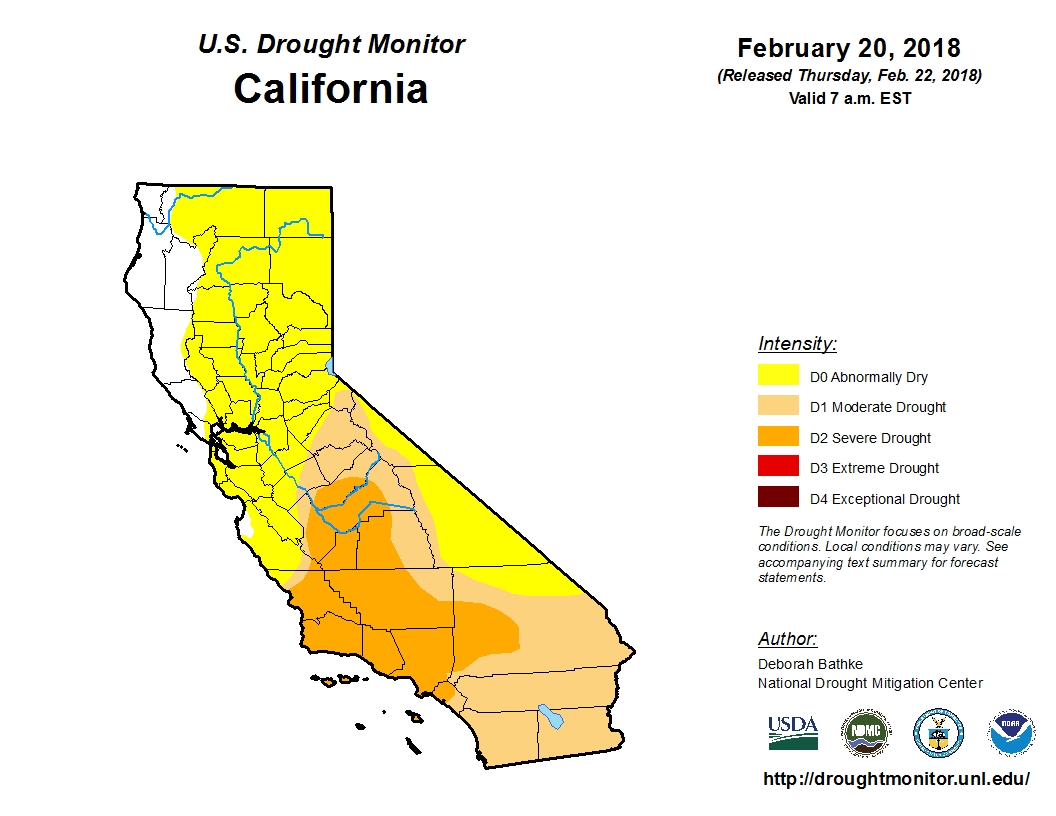
The U.S. Drought Monitor now has nearly 48 percent of the state categorized as being in at least “moderate drought.” More than 91 percent of the state is listed as at least “abnormally dry,” the precursor stage to drought.

US Drought Monitor map
Click image to enlarge. (Nat'l Drought Mitigation Center)

The term “drought,” is of course, highly subjective and has different meanings to different people. But the gradually returning shades of yellow and brown to the widely-cited map are unnerving to many, with the state’s most punishing drought on record so fresh in California’s collective memory.

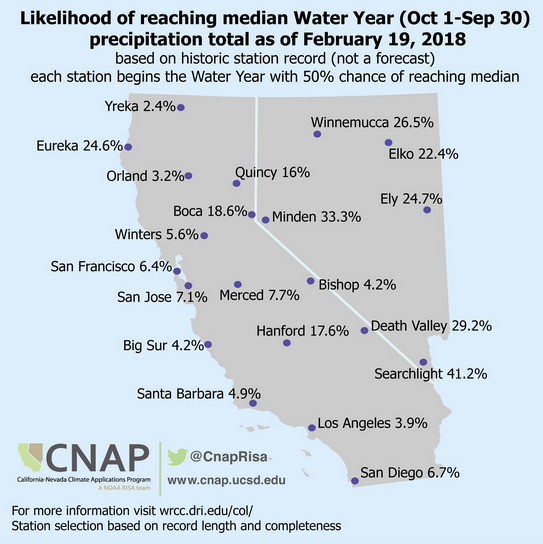
CNAP Probablities Map
By mid-February, a normal precipitation year was almost out of reach. (Western Regional Climate Ctr.)

The stage is certainly being set for some sort of drought. This week as the State Water Resources Control Board considered permanent statewide restrictions on a list of wasteful water uses, members were told that, measured by a key collection of gauges in the northern Sierra Nevada,  the January-through-February period has been California’s third driest on record (exceeded only by 1977 and 1991, when a “March Miracle” saved the wet season). It happens that those three months typically provide the state with half of its total annual precipitation.

In the central Sierra, this December through February is the driest on record.

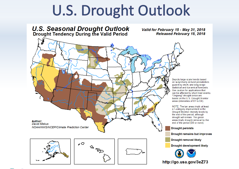
At the same time, forecasters at the National Oceanic & Atmospheric Administration project dry conditions to “develop or persist” in California over the next three months.

NOAA 3-mo. Drought Outlook map
NOAA’s three-month outlook does not bode well for California precipitation. (NOAA)

The weekly Drought Monitor maps are compiled by a rotating stable of authors, in consultation with various government agencies, and take into account more than 100 indicators. And while some have argued that too much weight is given them, John Leahigh, head of operations for California’s State Water Project told the water board that an “ugly picture” is beginning to form of the state’s current water year.

With the notable exception of Lake Oroville, which engineers have kept at cautiously low levels after last year’s near spillway disaster, major reservoirs remain flush from last year’s precipitation. But Leahigh told regulators that expectations are “dramatically decreasing” for runoff from the state’s key watersheds to replenish water supplies this year.

Viewing all 77 articles
Browse latest View live


Latest Images