Some eateries had already implemented an “only-on-demand” water policy before it was made mandatory –but many had not. (Craig Miller/KQED)
The nozzle just got tightened a bit on water use in California — but only a bit.
Regulators today added new restrictions to those put in place last summer. Urban water customers will have a few more “don’ts” added to the list that came out last July, which includes prohibitions on things like washing your car without a shutoff nozzle and hosing down “hardscapes” like sidewalks and driveways.
The new measures, approved by the State Water Resources Control Board, are a set of minimum standards for local water agencies, which have broad latitude to set and enforce conservation measures. Under the new rules:
Restaurants may only serve water if customers ask for it
No outdoor watering within 48 hours after any rain
2 day-per-week cap on watering lawns and landscaping
Local agencies will have 45 days to comply. Outside watering is a prime target as it makes up 44 percent of total urban water use. Local agencies have some flexibility with the two-day rule if they already have similar restrictions in place to achieve the same ends.
There are also new reporting standards for local water agencies on restrictions they’ve put in place and agencies are required to notify customers with known water leaks on their properties.
‘In this fourth year of drought, we’re going to have to move to a little more aggressive — or maybe a lot more aggressive responses.’ Peter Gleick, Pacific Institute scientist
All of the measures seem tame compared to recent calls for statewide rationing, such as the one by NASA earth scientist Jay Famiglietti recently in the Los Angeles Times.
“Those things, frankly, are going to have very minor impacts on total water demand but they raise awareness,” added Peter Gleick, who heads the Oakland-based Pacific Institute, a water policy think tank.
“In this fourth year of drought, we’re going to have to move to a little more aggressive — or maybe a lot more aggressive responses,” Gleick told KQED’s Forum program.
“We’ve been trying to take modest measures to sort of light a fire under local agencies,” says Felicia Marcus, who chairs the Board, essentially the state’s final arbiter of most water matters. “My hope is that in this fourth year they will act.”
Much was made last summer of new fines of up to $500 that could be slapped on egregious water wasters, but it’s unclear from talking to regulators if even one such fine has been assessed — hence the new requirement that local agencies report such actions to the state. Marcus says her board was never beating the drum for big fines, but she adds, “I think local communities should be taking much more dramatic action.”
The staff report prepared for the board members said that “additional benefits will be realized” from the latest round of measures, but staffers conceded that it’s not possible to “finely calculate” the savings, partly because of the lack of data available.
The new actions come as the state’s primary trade group for local water agencies released a poll on Californians’ attitudes toward water conservation. According to the survey commissioned by the Association of California Water Agencies, 80 percent of those surveyed say the drought has already caused them to reduce water use, and two thirds say there is more they could do.
After a record-dry January, California is on track for a March that is also in record-dry territory.
And the state Department of Water Resources says we may be looking at the skimpiest Sierra snowpack on record.
Felicia Marcus chairs the powerful State Water Resources Control Board. (Families Protecting the Valley)
None of this has been lost on Felicia Marcus, who chairs the State Water Resources Control Board. When water supplies are tight, as they are now, her board is where the buck stops in arguments over who gets what.
I sat down with her to find out where we go from here.
Craig Miller: Your senior scientist at the Water Board has said that it’s “hard to overstate the severity of this drought.” How would you characterize it?
Felicia Marcus: It’s the worst thing that any of us have dealt with — probably worse than anything our grandparents ever dealt with, for a number of reasons. The precipitation levels have, of course, been terrible. Our reservoirs are low and you can see that graphically. Our snowpack is even worse. And so the dislocation caused by multiple years of low precipitation — particularly the fact that it’s been so warm and we don’t have snowpack — is like a double whammy.
People will quibble about precipitation levels and look at 1924 and 1977 as technically having less precipitation than now. That is nothing to have a party about because there are millions more people than there were relying on that water. So we have communities running out of water, we have hundreds of thousands of acres of fields that have been fallowed, we’ve got thousands of people out of work and we’ve got fish and wildlife suffering as never before.
FM: Let me start with my most fervent hope, which is that local water agencies will begin to act as if we might have a “millennial drought,” like Australia. I think people were hoping for rain, which is not a strategy.
Marcus says local water agencies were “dithering” over what to do, so last summer, her board stepped in with a first-ever set of statewide minimum rules for water use. Beginning in May, they’ll tighten the screws a little bit more.
That will mean, among other things, people will have to ask for water at restaurants, and local water agencies will have to limit days in which lawn and landscape watering are allowed — in some cases to two days a week. It’ll be up to local water officials to adapt and enforce the rules.
CM: It’s the first time that the state has set a sort of minimum bar.
FM: First time any state has actually stepped in and set minimum conservation levels, but we felt we had to — not to control and tell everybody what to do, in fact they were quite modest — but to ring the bell and give some permission to the local agencies. And what I said was, “If you’re worried that your customers are gonna be mad at you, blame me. You know, I don’t mind if they’re mad at me.” It’s better if we act now.
CM: There also seems to be a gap between the rules and enforcement part of that. Much was made a year ago about $500 fines. To your knowledge, has anybody been fined $500?
FM: You know, I’ve heard anecdotally that there have been $500 fines. We weren’t intending to say, “Thou shalt fine.” We were actually enabling locals who maybe didn’t have the authority — we were giving them the authority to go up to $500. Some go to a thousand, some shut off your water. Again, this is something that localities do in different ways.
CM: Here we are in Year 4 and we’re just talking about saying to restaurants, “No, you can’t automatically bring a glass of water to every table.” Honestly, isn’t that something we should’ve done in Year 1?
FM: Well, absolutely, I mean there are communities all over the state that have been doing it for years and they’ve never undone it — and that is the right thing to do. Again — what’s appropriate for the state to do and what’s appropriate for the locals — and we’re trying to tread somewhat lightly. Our goal isn’t a statewide takeover of every urban water agency. But in a time of crisis, we need something that’s more visible. It sends a recurrent message that we’re in a drought because part of our challenge is, it rained a lot in December, so people may have thought the drought was over.
You can hear a longer version of our interview with Felicia Marcus by clicking on the audio player at the top of this post.
Barren mountainsides around Donner Lake in late February. (Joanne Elgart Jennings)
We are officially in uncharted territory — in more ways than one.
The Sierra Nevada snowpack, which typically supplies nearly a third of California’s water, is showing the lowest water content on record: 6 percent of the long-term average for April 1. That doesn’t just set a new record, it shatters the old low-water mark of 25 percent, which happens to have been last year’s reading (tied with 1977).
Things are so bad that Governor Jerry Brown decided to slog into the field for the manual snow survey on Wednesday morning. He didn’t need snowshoes but he did bring along a first-ever executive order mandating statewide water reductions.
“We’re in a historic drought and that demands unprecedented action,” he told reporters who made it to the Sierra survey site off of Highway 50.
The 31-point program is wide-ranging, though direct actions are focused on urban water consumption, aiming for a “mandatory” 25 percent reduction compared to 2013 levels. It will be up to the State Water Resources Control Board and more than 400 local water agencies to work out how to implement and enforce the mandates.
The initiative also includes new incentives for replacing lawns with drought-friendly landscaping, consumer rebates for water-saving appliances, and special assistance for residents whose wells have run dry.
While the state’s Department of Water Resources does monthly snow surveys during the winter season, the April 1 survey is the benchmark for assessing the season as a whole. That’s when snowfall is reckoned to have peaked and the runoff season gets underway. Six percent on April 1 is essentially saying there’s next-to-nothing to show for an entire winter’s snow accumulation.
The snowpack has now seen four years of steady decline. 2013 was California’s driest year on record. 2014 was dry too, but also the warmest on record, which combined for a one-two punch to California’s water supply. In March, for example, both Sacramento and Redding logged average temperatures more than 10 degrees above normal, according to consulting meteorologist Jan Null of Golden Gate Weather Services.
“There will be consequences,” says Mark Cowin, who heads DWR.
More than 400,000 acres of farmland were fallowed last year because of scarce water. Credible sources have estimated that figure could double this year.
“More impacts to farms where supplies will be shorted,” predicts Cowin, “more local communities where wells will run dry, and we’ll have to help assist them in some sort of emergency response, and more impacts to fish & wildlife, which is of course, very important.”
Groundwater resources will be stressed even more, as water-constrained farmers turn up the pumps to offset cuts in allocations from state and federal water projects.
Though Cowin hastens to add that “the vast majority of our citizens will not run out of water,” some already have, mostly in rural areas where wells have gone dry.
“I hope that this will continue to be a wake-up call for people that things are different,” says Lester Snow, a former DWR chief who now heads the non-partisan California Water Foundation.
“And not only is it gonna be bad this year but let’s not pretend that next year’s gonna be a lot better,” he added. “This drought has revealed fundamental weaknesses in our drought management system, and we need to start addressing those weaknesses.”
Other impacts from the paltry snowpack will be more subtle, such as the loss of hydroelectric power. Less runoff coming down the hill, turning hydropower turbines means that utilities have to replace the electricity, which they usually do with natural gas-fired power plants. That wields a bigger carbon footprint and adds to Californians’ electric bills — $1.4 billion since 2012, by one estimate.
Lawn sprinklers in San Francisco’s Golden Gate Park, in April. (Justin Sullivan/Getty Images)
Governor Jerry Brown’s decision to put his foot down was well timed.
Reports from local water agencies around the state show that on average in February, Californians did their poorest job at conserving water since the state began tracking water use last summer. Urban water savings in February were 2.8 percent, compared to the baseline year of 2013.
Conservation efforts peaked in December at just over 22 percent savings, but December’s weather skewed the results, as property owners cut back on watering amid persistent rains.
On a per-capita basis, the State Water Resources Control Board reported that Californians’ use of water actually rose in February, from 73 gallons per person, per day, to 77 gallons.
The averages conceal the progress that many communities have made. Livermore, Tracy, Stockton and Roseville, inland cities with relatively warm temperatures and abundant lawns, all made regulators’ honor roll of towns that cut water use more than 15 percent and reduced the closely watched per capita use to under 60 gallons per day.
Still, water board chair Felicia Marcus says she finds the broad numbers “sobering and disheartening.” Recent statewide polling indicates that Californians are ready to roll up their sleeves to save water. A March survey by the Public Policy Institute of California found that water and drought remain at the top of Californians’ concerns, tied with jobs and the economy, and that fully two-thirds say they don’t think enough is being done in response to the drought.
Against this backdrop, officials face the task of figuring out how to implement the governor’s 31-point conservation mandate, announced on April 1. Marcus said the governor was aware that the February numbers would be “bad” before he unveiled his new program.
“We have a very tight timeline for trying to implement this order from the governor,” says Max Gomberg, a senior scientist at the water board.
Aspects of the mandate remain murky, such as the proscriptions on landscaping for new homes. By mid-May, regulators hope to have specific regulations in place to achieve Brown’s goal of 25 percent water savings across the board.
Under the plan, the state will assign localities specific reduction targets based on how they’re already doing in terms of per-capita daily water consumption. Under a proposed framework for the regulation, targets would range from 10 percent for the most efficient areas, such as San Francisco and Santa Cruz to 35 percent for persistently heavy users such as Hillsborough and West Sacramento. Much of Southern California is at the high end, though officials cited San Diego as a standout water saver.
All told, officials say that Californians have saved 148 billion gallons of water since conservation efforts began in earnest last summer. Gomberg says that’s a year’s worth of water for two million people.
To see how your city stacks up, view the full list of proposed mandatory conservation targets.
In the summer of 1976, the Department of Water Resources installed an emergency rock barrier in Sutter Slough. (California Department of Water Resources)
It’s something they haven’t resorted to since the 1970s.
As California’s monster drought drifts into its fourth year, state water managers are taking a drastic step to keep much of California’s water fit for drinking. The Department of Water Resources says it will have to construct at least one barrier to keep salt water from encroaching deep into the Delta.
This is one of those extreme drought years when there may not be enough natural flow in the rivers to push back the incoming tides. Officials say the “salinity barrier,” northeast of Oakley in Contra Costa County, will help keep that brackish water from mixing with fresh water used for drinking and irrigation.
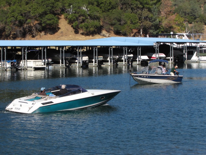
There will be costs, financial and environmental, and even recreational; the barrier will be a temporary roadblock to boaters.
Officials estimate it will cost $28 million for what is essentially an engineered rock pile, to be constructed in May and then taken down again in the fall. Then again:
“You don’t want salt in your water,” says Randall Baxter, a Stockton-based senior biologist supervisor with the California Department of Fish & Wildlife.
The strategic spot chosen for the barrier is a 750-foot-wide span of the West False River, less than a half-mile from where it meets the oncoming San Joaquin. It’s a kind of gateway to an area known as Frank’s Tract, which in turn leads to the huge pumps that draw freshwater for urban customers and farms. If salt water makes it that far, instead of washing back out with the ebb tide, it can often be trapped there, where it threatens drinking water supplies.
Baxter says there are potential costs to the already teetering Delta ecosystem, particularly for migrating salmon and steelhead.
“There are still fish coming through the system and will be for a while,” he says. “Putting a barrier in False River cuts out one of their emigration routes.” Baxter says it can also make the fish more vulnerable to predators.
The environmental effects could be a mixed bag of good and ill. As Ellen Hanak and Jeff Mount write in a recent post from the Public Policy Institute of California’s new Water Policy Center:
The water savings could also benefit some salmon runs, because more cold water could be saved upstream for release later in the year. But this approach will also involve new trade-offs, because reductions in Delta outflows are likely to harm delta smelt as well as salmon migrating through the Delta. This is yet another example of the tough decisions water managers are having to make during these exceptionally dry times.
Mount and Hanak note that of the roughly four million acre-feet of water that made it through the Delta without being diverted last year, more than 70 percent of that volume was required just to keep salt water pushed back toward San Francisco Bay.
Lawns and medians are in the crosshairs of California’s new mandatory water restrictions. (iStock/Getty Images)
California’s strategy to cut water use by 25 percent is a work in progress.
On Saturday, regulators charged with implementing Gov. Jerry Brown’s sweeping mandate for statewide water savings issued a revised plan based on more than 250 comments they received, many asking for changes in the preliminary framework issued in early April.
The new plan, drawn up by the State Water Resources Control Board, doubles the number of “tiers,” or conservation levels that local water agencies will be required to attain in the coming year. Cities will now have thresholds ranging from 8 to 36 percent, separated by smaller increments. Officials say the new structure will “lessen the disparities” between agencies.
Though the new draft reassigns some local agencies to lower conservation targets, the highest number — 94 agencies, or nearly a quarter — are assigned the most stringent requirement of 36 percent water savings — for now. Only 23 agencies, including the San Francisco Public Utilities Commission, are in the most permissive 8 percent tier.
Breakdown of water saving thresholds that may be assigned to cities. R-GPCD refers to residential use measured as gallons per capita, per day. (SWRCB)
In addition to revising the tier structure, new provisions include softer treatment for some special cases:
Agriculture-intensive areas: The “handful” of suppliers that are classified as urban agencies but send more than 20 percent of their water to commercial agriculture can exclude the farm water portion from their savings calculations.
Water-flush areas: The relatively few spots, mostly on the North Coast, that are “not experiencing shortages” can petition for assignment to the lowest tier if they demonstrate that they have a multi-year supply available.
Small suppliers: Utilities with more than 15 but fewer than 3,000 connections have a separate, less exacting standard.
The carrot: Cities that achieve high savings can ask to be reassigned to a special Tier 1, which carries only a 4 percent reduction threshold. No water agencies are currently in Tier 1, which is reserved for high achievers.
Water board chair Felicia Marcus says the special provision for agriculture-intensive suppliers is the fair thing to do, despite the “distracting and incorrect soundbites” in recent media coverage that imply that farms are getting a free pass. Marcus has repeatedly said that the farm belt is being cut back on water, but under a different mechanism.
Commercial and industrial users won’t be asked to cut into water use that’s essential to their businesses but will be asked to “target” discretionary use such as watering of ornamental landscapes on their properties. As to how that will be managed, Marcus says, “We’re leaving that judgment to local agencies.”
Asked what residential water consumers or “end users” should be doing right now in response to the governor’s April 1 mandates, Marcus responds: “More of the same and doubling down.”
Officials continue to invite comments through next Wednesday.
See how your town stacks up on the complete revised list of assigned savings thresholds.
Gov. Jerry Brown holds a news conference at the state Capitol after meeting with California mayors about new efforts to help local drought relief programs. (John Myers/KQED)
State regulators have come up with a “final” version of their gameplan to implement Governor Jerry Brown’s sweeping April 1 mandate to save water. This is the version that the State Water Resources Control Board will likely vote to approve during it’s two-day meeting next week.
The 31-point plan is aimed at cutting statewide water use by 25 percent on average, versus 2013 levels. It assigns local water agencies mandatory conservation targets based on how much water they’ve been using on a per-capita basis. The current range runs from a low of eight percent to a high of 36 percent monthly savings, starting this summer.
Individual cities and water districts have been lobbying for easier thresholds, touting their ongoing efforts to save water. But the newest revision of proposed state regulations appears to hold firm for the most part, on quotas that local water suppliers will have to attain.
One change allows local agencies to report total water use by commercial and industrial consumers, as opposed to breaking out the data by customer. Officials say they might revisit that once local agencies refine their data collection.
Just hours before the proposed regulation’s third iteration was unveiled, Brown emerged from a meeting with mayors from around the state with new legislation in hand that could help cities in their efforts to save water.
“There’s a lot to be done,” Brown told reporters, in California’s quest for drought resilience. The governor called this latest step, “another installment on a long enterprise to live with the changing climate and a drought of uncertain duration.”
The proposed legislation would add some “teeth” to local enforcement of new water conservation rules, including:
A new penalty of up to $10,000 per violation, up from the $500 per day maximum established last year
Broader authority to issue local fines without specific court approval
Latitude for local agencies to deputize “water cops” to enforce conservation rules
The legislation would also allow cities to fast-track environmental reviews for water-saving projects — but it did not appear that Brown was offering any easing of the new conservation quotas.
Regarding the steep jump in the maximum fine for water hogs, Brown said, “You can be sure that only the worst offender will be getting that.”
“Fines are a tool,” added Felicia Marcus, who chairs the water board. “And they’re the last tool you use.”
Marcus’ board will continue to take comments on the new drought regulations right up until the final vote, during a two-day meeting scheduled for May 5-6.
A lush lawn may be part of the American Dream–and the new California nightmare. (Craig Miller/KQED)
UPDATE: After an extended session on Tuesday, the State Water Resources Control Board approved final rules to bring about the 25 percent reduction in water use ordered by Governor Jerry Brown in early April. The statewide water restrictions go into effect on June 1.
“We know we’re not asking people to do things that are easy,” said board chair Felicia Marcus right before the unanimous vote.
“But this is the moment to rise to the occasion.”
Local water agencies are racing to get programs in place to cut urban water use anywhere from eight to 36 percent, depending on how much water their residents have been using on a per-capita basis.
But the actual savings that cities will have to achieve vary much more widely than that range of state-assigned “tiers” would suggest. Just as important are the savings achieved over roughly the past year.
The Silicon Valley city of Mountain View, for example, has been assigned a savings “tier” of 16 percent; that’s the reduction that local water officials will have to attain on on month-by-month basis, starting in June. But since Mountain View has already managed to cut water use by 15 percent, residents there will, in effect, only have to squeeze out another one percent savings to comply with the governor’s mandate.
A few locales — like Santa Rosa, Livermore, and Santa Cruz, have already exceeded their assigned levels and could theoretically use more water this summer and still comply with the drought mandate — not that anybody’s openly encouraging that.
Other cities have their work cut out for them. Water consumption in Lodi, for example, actually rose by one percent, so the city will have to cut back by slightly more than its assigned 36 percent target, which is the highest tier.
Last week, Governor Brown rolled out legislation that could help cities attain their assigned goals, ratcheting up maximum fines that local officials are allowed to assess for unrepentant water wasters.
It will be at least mid-July before there are indications of whether the new conservation measures are taking hold — just as the peak outdoor watering season is hitting its stride.
“And that’s when we really need to see significant reductions in outdoor water use,” warns Max Gomberg, a senior scientist at the State Water Resources Control Board. “If we don’t get those reductions during the summer, we’re simply not gonna make the overall reduction target.”
The governor’s April 1 list of mandates is designed to cut statewide water use by 25 percent, on average.
“You might think of this as just another installment on a long enterprise to live with the changing climate and with a drought of uncertain duration,” Brown told reporters after a meeting with California mayors last week. That last point is crucial; no one can say at this point whether we’re in the last year of a four-year drought, or year four of a ten-year “Big Dry,” such as Australians endured at the start of the century.
“People face different environmental challenges,” Brown said, “and out of this very complex state we’re gonna do everything we can to save water and to get it done.”
Getting it done will now be largely in the hands of local water officials and consumers. The state has weighed in; now it’s on us.
See the complete list of cities and their assigned water conservation targets.
“Brown is the new green” is the rallying cry for fighting the current drought. But will Californians take up the cause? (Craig Miller/KQED)
The clock is ticking.
After state regulators approved California’s first-ever statewide water restrictions on Tuesday, it’s now up to nearly 3,000 local water agencies, big and small, to make it work.
Water agencies throughout California bear the burden of achieving the 25 percent reduction in water use ordered by Governor Jerry Brown on April 1. The state will start keeping score officially on June 1, when cities and water districts need to start carving between eight and 36 percent off their 2013 water use, and keep it up on a month-to-month basis.
“You’re on the front lines, you know that,” Brown told a gathering of water managers at the Association of California Water Agencies in Sacramento. “And we’re here to back you up.” Brown, however, as much as admitted that it was easy for him to say.
“We just kind of launch the missile, and then you particularize and talk to your neighbors, and get ’em to do it.”
Or not. When it comes to the hard choices such as tearing out lawns, replacing water-gulping toilets and appliances, it remains to be seen how Californians will respond.
“What worries me most is that I think a lot of Californians are not yet quite ready to do that,” says Dave Bolland, who manages special projects for ACWA, “to embrace that new water use ethic.”
State figures indicate that another 25 percent water savings could be a tall order for California consumers. (State Water Resources Control Board)
Recent conservation trends would seem to bear him out. According to figures gathered by the state water board, water savings averaged only 3.6 percent in March, compared to 2013 levels of water consumption. That’s far below the 20 percent voluntary cutbacks that Brown asked for a year ago, and even more dismal compared to new targets that individual communities will now be required to attain.
“There are some very aggressive targets in this mandate,” notes Bolland. More than 80 local agencies have been assigned the highest, 36 percent, savings quota.
Many cities have gotten a head start and some, like San Francisco and Santa Barbara, are already ahead of the quotas assigned to them by the state. But others are still worried about the impact on their local communities.
“Going down to one day a week watering, we’ll be seeing brown lawns, we’ll be seeing a lot of vegetation dying,” Jennifer Hanson told the state water board in a last-ditch appeal on Tuesday. Hanson heads public services for the city of Lincoln, northeast of Sacramento, which has been assigned to the highest “tier” of required conservation. She says even cutting outdoor watering to one day per week might not be enough to meet her local mandate.
“Trying to go down to zero days a week watering to try to meet our 36 percent on average throughout the year, may even require more stringent measures for outdoor water use.”
Cutting 36 percent of deliveries will also strike a major blow to revenues, even as water agencies are expected to promote and enforce conservation, which will mean selling less water.
“There are a lot of agencies that, you know, that’s a third of their resources in terms of their water revenues, so there are substantial fiscal impacts,” says Bolland. “So there are some significant challenges that these water agencies face.”
But business-as-usual isn’t an option, says Brown. “We’ve got to change,” he told the ACWA gathering. “And how we use water is not exempt from that.”
Moon rise behind the San Gorgonio Pass wind farm, 2009. Promoting renewable energy sources like wind and solar is part of the climate pact signed by Governor Jerry Brown and about a dozen other subnational governments. (Chuck Coker/Flickr)
California is adding to its roster of allies in the climate change counteroffensive.
Environmental groups are hailing an agreement signed Tuesday by Governor Jerry Brown and an assortment of states, provinces and other “subnational” governments to ratchet up their own climate strategies.
Billed as the “Under 2 MOU,” the memorandum of understanding is a pledge to advance policies aimed at arresting global warming at the U.N.’s critical threshold of 2 degrees Celsius. That’s the level beyond which some scientists say the most catastrophic effects of climate change would kick in and hence, has been widely adopted as a kind of holy grail of climate policy outcomes.
Even assuming that all parties deliver on their pledges, actually holding the line at 2 degrees would, of course, require serious, sweeping transnational commitments from major emitters like the U.S., China and India, something that negotiators have yet to achieve.
KQED’s Tara Siler spoke with Dan Kammen, who heads the Renewable and Appropriate Energy Laboratory at UC Berkeley, about the deal and how much difference this kind of subnational agreement can really make in moving the climate needle.
One tenet of the agreement is the establishment of mid-term emissions targets “to support long-term reduction goals.” Brown set out a series of ambitious climate goals in his January inaugural message, and more recently set a target to cut greenhouse gas emissions to 40 percent below 1990 levels by 2030. The state had already adopted a 2050 goal to cut warming emissions by 80 percent.
Joining Brown in signing on to the MOU are representatives of provincial governments in Canada, Brazil, Germany, Mexico, Spain and the United Kingdom, as well as state officials from Oregon, Washington and Vermont. Previously Brown had cobbled together a West Coast climate action collaborative with Oregon, Washington and British Columbia. Provincial officials in France were expected to sign on as well.
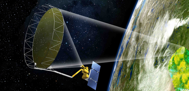
NASA’s SMAP satellite will capture microwave radiation from the Earth to measure soil moisture. (NASA)
Thursday morning a rocket was scheduled to lift off from Vandenberg Air Force Base on California’s Central Coast, tricked out with instruments that could provide better weather forecasts and more clues to where the drought is headed. (Update: NASA rescheduled Thursday’s launch for Saturday due to high winds and technical problems).
It’s not one of NASA’s catchier names, but the satellite known as SMAP, for “Soil Moisture Active Passive” is designed to provide — for the first time — highly precise maps of water stored in topsoil around the world. Scientists say that’s an important cog in the planet’s water cycle.
“Much like when you perspire, your sweat evaporates and cools your body,” offers Kent Kellogg, the mission’s project director at the Jet Propulsion Lab in Pasadena.
“As it evaporates it seeds the atmosphere with moisture, so that clouds can form, and then precipitation can occur.”
From more than 400 miles up, SMAP will measure differences in natural microwave radiation coming off the Earth. Kellogg likens it to a big pair of night vision goggles in the sky, but measuring radiation on a much lower frequency (so, no, it doesn’t mean NASA can watch you skulking around at night). Wetter soil is cooler and drier soil warmer. From that, scientists can derive water content accurate down to about 6 square miles. Kellogg says that could improve local flood forecasting and drought management.
“If you know how much water is in the soil, if you think of soil as a sponge and you know how full of water that soil or that sponge is, you can have a much better prediction of the likelihood for flooding to occur,” explains Kellogg.
Currently soil moisture is mapped using a relatively sparse network of individual ground-level probes. SMAP will constantly map soil conditions globally. Record high temperatures have stoked evaporation from soils, making California’s current drought even worse.
“SMAP will give us a much more accurate measurement of the rate of change of drought-prone areas,” says Kellogg. “Are they getting larger or getting smaller?”
They’ve been getting larger in California lately, given the historically dry January that’s just winding down, with little precipitation on the horizon. Of course, it’s hard to see clearly more than about ten days out with current weather models. NASA expects SMAP to help with that as well, possibly adding days to the range of reliable regional forecasts.
“Understanding soil moisture conditions in regional areas can give us a lot of insight into the likelihood for rain to form and for the regional temperatures,” says Kellogg.
But SMAP will have its limitations.
“We do not expect to use SMAP data at this point,” says Roger Bales, a climate scientist at the University of California, Merced, “in part because we do not expect it to provide relevant soil moisture information for the areas where we work.” Bales has spent years developing a ground-based network of sensors to measure soil and other hydrologic conditions in the Sierra Nevada, much of which is heavily forested.
“SMAP has some limitations on measurements of soil moisture when the soil is covered by canopy,” or snow in a wet year, Bales points out. “We also understand that SMAP will mainly measure moisture in a thin surface layer of soil, and our interest is more on the deeper soil profile.”
But with its 20 or so ground passes per day, Kellogg expects SMAP to provide useful data on more exposed ground, such as the millions of acres of irrigated land in California.
SMAP will be the fifth and final addition to a suite of recently launched earth science satellites that track attributes ranging from precipitation to the carbon cycle.
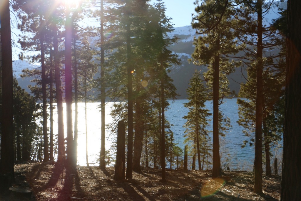
Barren shores remain in January at Fallen Leaf Lake, more than 6,000 feet above sea level in the northern Sierra. (Joanne Elgart-Jennings)
Manual surveys on Thursday confirmed concerns over the withering mountain snowpack — a critical source of water for millions of Californians. Statewide, water content in the Sierra’s accumulated snows is an anemic 25 percent of the average for this time of year.
That’s despite a really soggy December in which some California cities got nearly three times their normal rainfall — and rainfall is the operative word. But those storms weren’t cold enough to deliver much snow to the middle elevations. 2014 went down as California’s warmest year on record.
“The temperature side of things should not be neglected here, says climatologist Kelly Redmond, who has been tracking patterns in the Sierra for 25 years at the Western Regional Climate Center in Reno. “It has its own consequences that sort of stack on top of the precipitation deficits.”
In the Lake Tahoe region, Redmond says the “freezing level” — the elevation at which temperatures dip to freezing — has hovered at around 10,200 feet, or about 3,000 feet higher than the long-term average. That means less snow stored in the high peaks for use this summer.
Follow that with what is now looking like a record-dry January for most of the state — and you’re left with a snowpack that is little more than a quarter of what’s normal for this date.
The good news: we’re in better shape than we were last year at this time but still far, far behind the kind of winter that all the experts said we would need to even begin to reverse the drought. While, thanks to December’s deluge, many cities in the Central Valley remain slightly ahead of normal for the season so far a closely-watched index of eight gauges in the northern Sierra — a key indicator for some of the state’s biggest reservoirs — has slipped below its average for late January, with little indication of major storms on the horizon.
So while might be tempting to say, “Hey, what’s the problem — we’re running just about average,” state water managers have said California would likely need upward of 150 percent of its average precipitation to start turning things around. And time is running out. The occasional “March miracle” notwithstanding, the rhythms of California’s Mediterranean climate are such that precipitation typically starts tapering off after February.
This video from the state Department of Water Resources shows how patchy the snow cover is, even around 7,000 feet of elevation. The “12 percent of average” that surveyor Frank Gehrke mentions is the reading from the single snow course where the video was shot, not the statewide number.
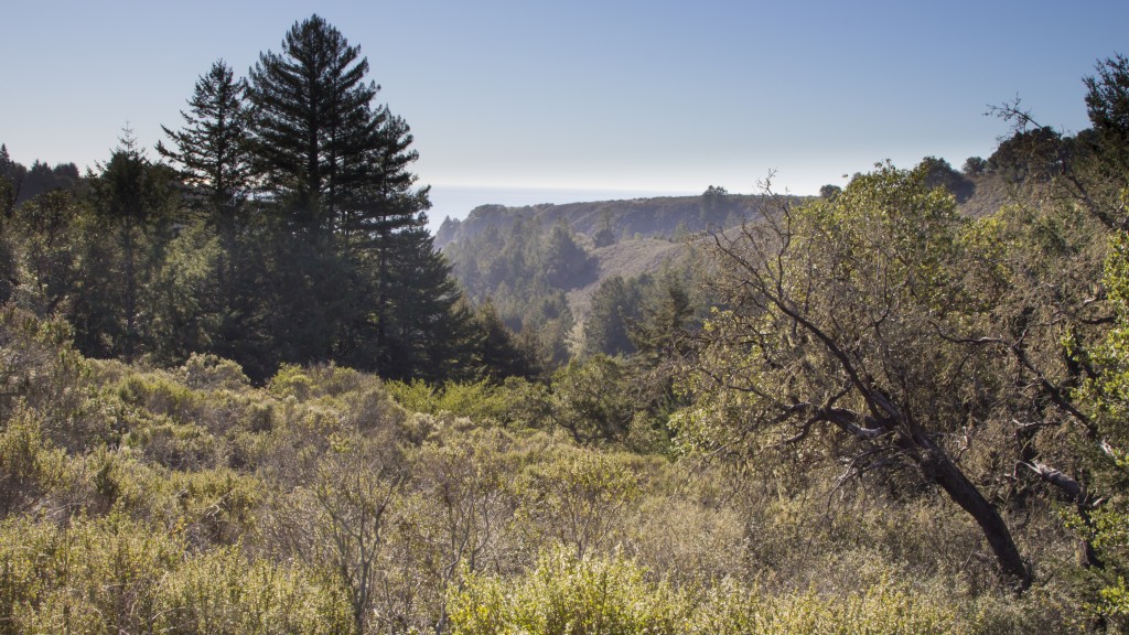
Conservationists are hoping to set aside nearly 6,000 acres for a Santa Cruz Redwoods National Monument. (Mike Kahn/Sempervirens Fund)
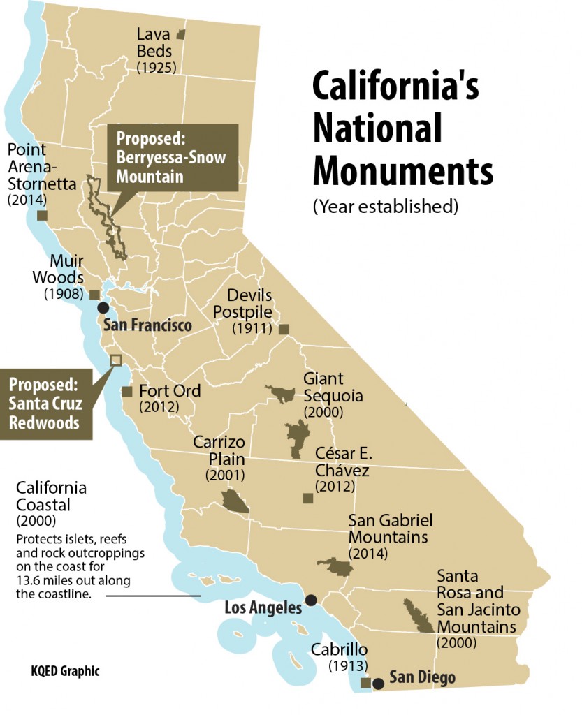
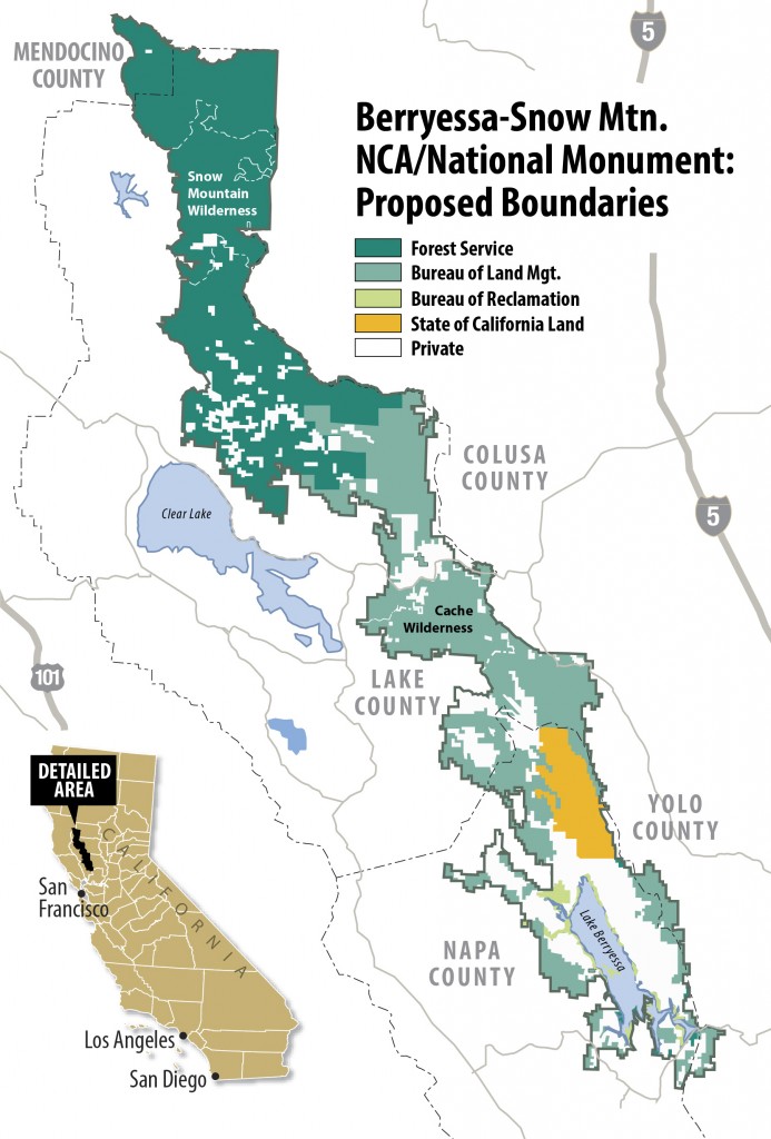
This month, Congressman Mike Thompson (D-St. Helena) introduced — for at least the third time — a bill to set aside more than 350,000 acres north of the Bay Area as California’s newest national monument. Only this time, the footprint of the proposed Berryessa-Snow Mountain National Monument is minus Lake Berryessa, the man-made reservoir northeast of Napa which opponents say doesn’t merit special protections.
At the same time, environmentalists in California are pressing President Obama to use his own authority to protect hundreds of thousands of acres of federal lands from development by designating them as new national monuments.
There’s been a burst of activity on this front lately, with nearly 350,000 acres recently set aside for the new San Gabriel Mountains National Monument and stretches of the north coast recently added to the eclectic string of oceanside features known collectively as the California Coastal National Monument. While some of California’s 13 national monuments date back more than a century (see map), four were either established or expanded in the past four years.
This month, former Interior Secretary Bruce Babbitt was in Santa Cruz, stumping for a new monument there.
The push for the Berryessa-Snow Mountain lands is proceeding on dual tracks, seeking both presidential and congressional approval, whichever comes first.
Often, national monuments are established by executive order. Over the years, these designations have been both celebrated — and decried as an overreach of presidential authority.
As recently as this year, Senator Steve Daines (R-Montana) introduced an amendment to limit “unilateral” monument designations under the Antiquities Act.
But public lands expert John Leshy says most presidential designations have withstood the test of time, and have often been affirmed or expanded by Congress, after initial objections.
Leshy is the Distinguished Professor of Real Property Law at the University of California’s Hastings College of the Law in San Francisco. He was also the Interior Department’s top lawyer under President Clinton.
In the interview (click on the audio player above): Leshy clears up the difference between a national park and national monument, and talks about how history has judged the 1906 law that established presidential discretion over new national monuments.
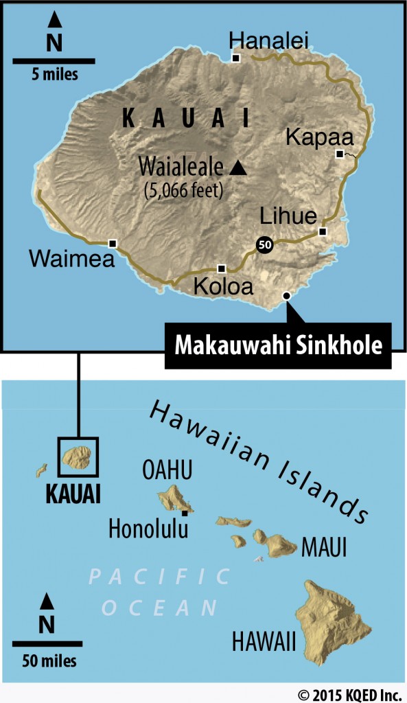
The Makauwahi sinkhole on Kauai, as seen from the caves on the south side of this hidden bowl. (Craig Miller/KQED)
Four years ago this week, an earthquake off the Japan coast unleashed a wall of water that devastated coastal cities there — and caused more than $50 million in damages along the California coast from Santa Cruz to Crescent City.
Especially vulnerable is the state of Hawaii, where scientists have been calculating just how big that threat might be, using evidence that could’ve gone completely unnoticed.
Hidden away on the south shore of Kauai, Hawaii’s geologically oldest island, is Makauwahi sinkhole, a small wonder amid the dense coastal vegetation. It also contains buried treasure for scientists who study Pacific tsunamis.
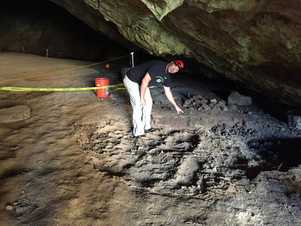
“It’s just a massive old sand dune that has — scientists will say ‘lithified’ — it’s become rock,” explains Chris Landreau, an archaeologist who’s worked on digs at the sinkhole. Emerging through a small cave on the north side of the bowl, it presents as its own tiny world, open to the sky, surrounded by sheer walls. Palm trees sprout from the floor of the crater.
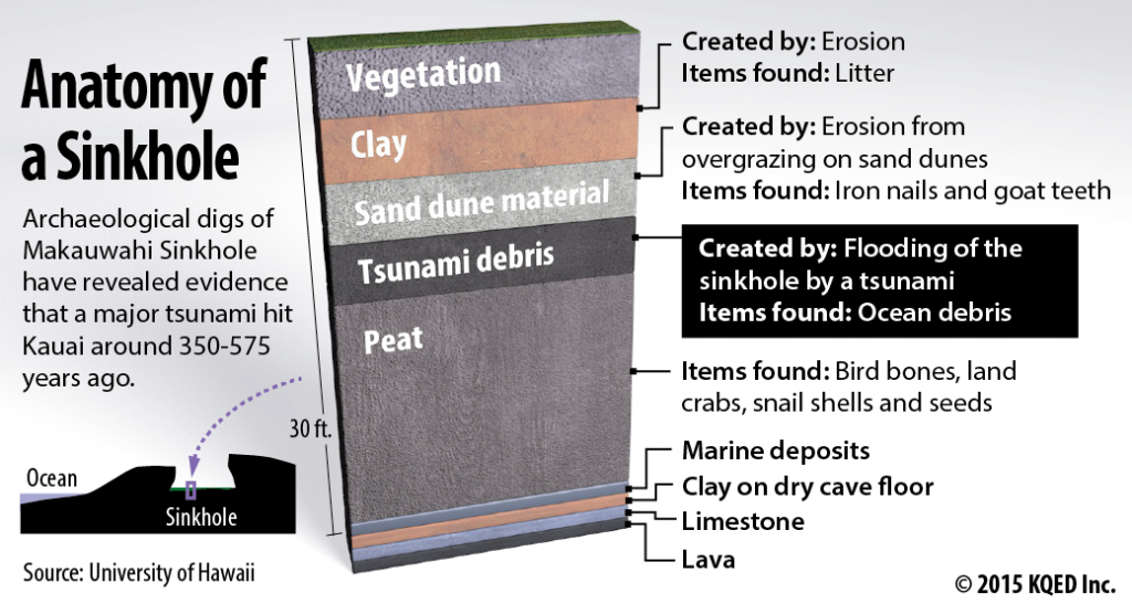
When biologists entered this world in the 1990s, they soon realized that it was an open time capsule for unmasking the island’s biologic and geologic history.
Paleoecologists starting digging down, sifting from the layers of sediments the comings and goings of plants and animals through time.
Seismic Paydirt
“The idea is to identify those things that are extinct,” Landreau says, “and to identify those things that we can still find somewhere locally, and try to revive them.”
That was the idea. But as they were digging, they struck seismic paydirt: a layer about a yard thick that clearly didn’t belong there. What was there — basalt cobbles, corals, shells and other ocean debris — eventually caught the eye of a geophysicist at the University of Hawaii named, yes, Rhett Butler (not to be confused with this Rhett Butler). He noticed that this was obviously stuff that came from the ocean, not the residue of plants and animals that would’ve lived on the island. And there was a lot of it.
“It’s a huge volume,” Butler says. He calculates about 600 cubic yards, or enough debris to fill nine ocean containers, the kind you see stacked up on cargo ships.
“It takes a heck of a lot to move that much material, move it from the beach, move it up the hill,” reasons Butler. “So the most likely scenario, quite frankly, is that it’s a tsunami.”
It would have to have been huge — big enough to hurl 200-pound boulders into a hole that’s two to three stories above sea level and set back from the shoreline about the length of a football field. Butler reckons that it hit Kauai sometime between 350 and 575 years ago.
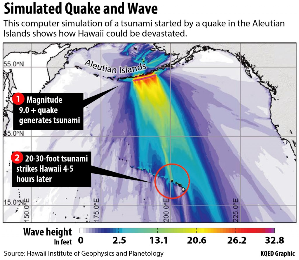
Butler began using computer models to trace such a tsunami back to its probable origins. That led him to a seismically active zone nearly 2,000 miles north, in the eastern Aleutian Islands, off Alaska.
“And the shape of the subduction zone,” he notes, “in other words where the Pacific and North America converge together — if you look at that geometry, it basically focuses energy directly toward Hawaii.”
His modeling work points to a quake bigger than magnitude-9 — that’s 100 times more powerful than San Francisco’s Big One in 1906, or at least as powerful as the 2011 Tohoku event that savaged coastal Japan.
“It’s a similar sized event to Tohoku, maybe slightly bigger,” Butler estimates.
In fact, he thinks it might’ve been the Pacific’s biggest quake in the past 7,000 years. At the rate that tectonic plates near the Aleutians have been moving since the Kauai tsunami, he calculates that the region is capable of producing a similar quake, at any time.
Archaeologist Chris Landreau points out some of the tsunami deposits at the edge of caves on the south side of the sinkhole. (Craig Miller/KQED)
“Once you start modeling it and looking at the possibilities,” Butler says, “you realize it’s not unreasonable that we could get a magnitude-9 in the worst possible spot that would make all the other events look rather small in comparison.”
While a tsunami of that size 500 years ago would have been devastating to Hawaii’s primitive coastal culture, today civil defense authorities estimate that 370,000 people and $40 billion worth of infrastructure stand in harm’s way in the islands’ existing tsunami zones.
“For California, a tsunami is a nasty event but it happens within a mile of the coast,” Butler says. “The rest of the state is not affected. One of these things in Hawaii devastates the whole state.”
Partly as a result of Butler’s work, Hawaii officials are in the process of redrawing tsunami maps to take into account the possibility of something much bigger than is in the historical record.
“Basically letting the people know where the safe zone is, which is the essence of the whole thing,” he says. “It’s to save people’s lives.”
Computer modeling shows how an earthquake in the eastern Aleutian Islands would focus tsunami energy toward Hawaii. The green band above Kauai, in particular, shows how the contours of the ocean floor focus even more of the energy directly on the state’s northernmost island. Actual wave heights at landfall could be greater than colors indicate.
Technology to the Rescue?
A lot of progress has been made toward that end in the last 10 years or so. A network of ocean buoys and other sensors keep watch for tsunamis. The U.S. maintains 39 buoys and other nations have added about 20 more to the network, known as DART. But keeping them working in harsh ocean environments is a challenge. And currently about a quarter of the U.S. network is out of service.
Butler has suggested adding two more buoys to the Aleutian chain. Paul Whitmore, who directs the National Tsunami Warning Center in Palmer, Alaska, says there are no plans to do so, citing the costs involved. Butler has also suggested adding sensors to transoceanic cables that traverse the north Pacific. Whitmore says while officials have talked about that “for years,” deployment costs have been a barrier.
Meanwhile, Butler says were a similar event to happen today, “We only have, literally, 4 ½ hours. Imagine you snap your fingers and 4 ½ hours later, there’s a wave coming on shore that’s massive. So we’re very concerned about improving tsunami warning capabilities.”
Butler is seeking funding from the Federal Emergency Management Agency to search for other sites in the islands that would tell us more about this and other tsunamis in the distant past that might portend future events. Right now, Makauwahi sinkhole is the only evidence found of the mega-tsunami of 500 years ago.
By comparison, Butler muses that one small town in Oregon — Seaside — has “over 300 paleotsunami measurements of a former Cascadia event, whereas in all of the Hawaiian islands, we have precisely one.”
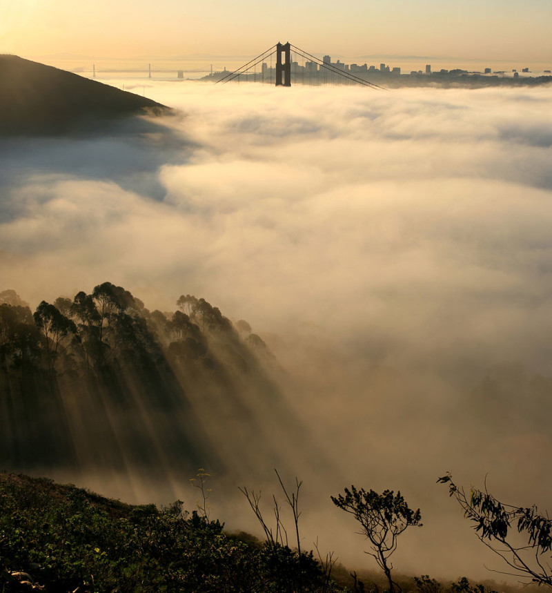
Fog season is with us once again. And whether it’s the ground-level “pea soup” of legend or the looming overcast known as the marine layer, there’s a reason it’s called California’s natural air-conditioning: fog and clouds are vital cogs in keeping the coastal thermostat turned down.
But that advantage could be disappearing.
KQED Science Editor Craig Miller talks with climate scientist Park Williams about his recently published work on California’s vanishing clouds. Williams is an assistant research professor at Columbia University’s Lamont-Doherty Earth Observatory in New York, but the gray mantle of the California’s summer coastline keeps drawing him back here — and it’s not just the romance of it. It turns out that fog — any kind of cloud, actually — is a great regulator not just of heat, but of drought.
Park Williams: Yeah, fog regulates drought. It does it in a couple of ways. In ecosystems, fog drops water directly on plants. And when the water collects on the plants, it then drops into the soil and is available for the plants to use. Fog, and clouds that are higher than fog, also shade the sun, and that allows plants more time to use the water they’ve collected from the fog. In cities, fog and clouds that are higher than fog — overcast clouds — are important as well, because they regulate surface temps.
Craig Miller: And it seems like cities are where the problem is.
PW: We looked at Southern California and found that in large cities — L.A. and San Diego — the heights of low clouds during summertime have been increasing; they’ve been rising away from the city.
CM: Why would that be?
PW: Cities have been warming, and essentially you need to go higher into the atmosphere before you finally get to where it’s cool enough to have water droplets condense and clouds can form.
CM: This is sounding like the “urban heat island” effect at work here. Is there a smoking gun for that?
Fog settles over San Francisco Bay, with the Golden Gate Bridge, Coit Tower and Bay Bridge visible in the distance. (Brocken Inaglory/Wikimedia Commons)
PW: The minimum temperature at night has been rising rapidly. During the daytime we’ve seen slow warming, but not nearly at the pace that nighttime warming is. That’s the fingerprint of the urban heat island that we expect. The urban heat island effect really is a nighttime phenomenon because cement takes a long time to get rid of its heat, and that causes nighttime temperatures to rise.
CM: And where urbanization reaches inland, like, say, the Inland Empire region east of L.A., this phenomenon seems to follow. For example, looking at readings from airports, you found there’s 87 percent less fog in Ontario since 1950, and that overall cloud cover — technically the “frequency” of clouds — has been reduced by about half. That’s stunning.
PW: That means Ontario is getting a lot more sunlight in the morning hours, which is then feeding back to heat up Ontario and make clouds less likely in the future.
CM: You’re describing a kind of vicious cycle.
PW: Clouds will become thinner over Los Angeles. That allows more sunlight to be absorbed by the ground, which causes more surface heat, which causes clouds to have to form higher up, which causes clouds to be thinner, which perpetuates this process of more sunlight, higher clouds — and eventually more sunlight, no clouds.
CM: But you don’t foresee fog and overcast vanishing everywhere along the coast, only in the most urbanized areas?
PW: It depends on where you are. Since these fog and low marine clouds during the summer are regulators of drought, and since global warming is projected to enhance drought in much of California, these clouds could be very nice moderators of the global warming process and increased drought in coastal California.
CM: But in the cities …
PW: Then we see basically the moderating effect of these clouds probably getting canceled out, and rapid increases of drought in the mountain ecosystems surrounding the cities of Southern California.
CM: It sounds like when you get north into the coast redwoods, which are so dependent on the fog, the prognosis isn’t so bad.
PW: I think it’s not so bad. We’ll have to wait and see. Certainly these clouds are complicated and there are aspects to them we still don’t understand so well. We’ve had a tough time getting computers to actually model the behavior of these clouds.
CM: It makes you wonder if we might come to miss the June Gloom.
PW: I think the ways it’ll be missed are — energy bills rise because everything’s warmer, heat waves will be warmer and that’ll have some public health implications. But there’ll be benefits, too. People like going to beach when it’s sunny and not cloudy, so June Gloom gets in the way of family vacations. It’ll be nice to have better beach weather.
CM: I’d call that a silver lining except I think you need a cloud for that.
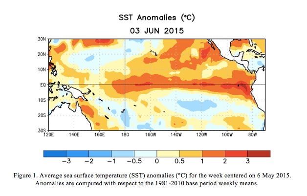
Though it’s still early in the game, forecasters say all the elements are in place for a whopper El Niño that could bring substantial rain and snow to California this fall.
Federal forecasters say there is now a 90 percent chance that the warm-water ocean conditions will prevail into the fall, and an 85 percent chance that they’ll endure throughout the coming winter.
“It’s quite well established now in the Eastern Tropical Pacific Ocean and it appears to be strengthening,” says Stanford climate scientist Daniel Swain, author of the popular California Weather Blog.
Now forget that you read this.
One of California’s top water regulators recently complained that El Niño hype last spring threw a monkey wrench into efforts to promote water conservation.
“This killed us at the beginning of 2014,” Felicia Marcus told reporters in a May conference call. Marcus heads the State Water Resources Control Board, which has been charged with implementing Governor Jerry Brown’s statewide water restrictions.
“Everybody wrote the story that El Niño might save us, so people didn’t start conserving when they should have.”
As it happened, last year’s El Niño, eventually dubbed “El Wimpo” by weather wags, remained too weak to overcome the prevailing drought conditions; the hoped-for rains never arrived.
“You can hope for it but you certainly can’t plan for it,” said Marcus.
NOAA graphic shows the warm plume of water running east-west near the equator, the classic signature of El Nino. (NOAA Climate Prediction Center)
But scientists say this year looks more like the real deal.
“Everything is certainly in place for this event to continue,” says Mike Halpert, deputy director of NOAA’s Climate Prediction Center.
“Right now the indications are that it will continue to strengthen and that this will be in place, in fact, next winter,” agrees Swain.
But that question of strength is crucial. As we’ve reported here before, only the stronger El Niños translate to wet winters in California. Strength is measured according to how much ocean temperatures deviate from the norm. The difference between one degree and two degrees Celsius above average can be enormous in the “teleconnections,” the term scientists use to describe distant weather effects from El Niño. Right now this one appears to be building strength.
“It still doesn’t mean that it’s a slam dunk strong El Niño forecast,” says Swain, “but it does mean that this year we have higher confidence than we did last year.”
Some of that confidence is driven by the atmospheric effects of the current El Niño, a connection that never quite took hold last year. What’s happening in the ocean now is encouraging — but it has to keep happening for several months to come.
Halpert says there’s a slightly better-than-even chance that we’ll see a strong event take shape. But while it’s tricky enough to forecast the staying power of an El Niño, handicapping its strength several months hence is even harder.
“I think it takes more than just having the pieces,” he cautions.
“I think it almost takes some level of — I hate to use the word luck — but that somehow everything just falls together and that’s just not something that we’re able to forecast.”
A 360,000-acre patchwork of federal lands north of the Bay Area may yet become California’s next national monument, but it will happen without a major component — or so it seems.
“We can’t know for sure,” says Bob Schneider, senior policy director at Tuleyome, a Woodland-based conservation group that’s been pushing for the monument for at least seven years.
A spokesman for Representative Mike Thompson (D-St. Helena) has said only that Thompson made the call himself before reintroducing his bid to create the monument in January. Supporters have been pursuing a “dual track” to monument status, seeking both a presidential designation and congressional action.
But Thompson’s latest version of the bill, which remains stalled in committee, is murky on the status of the the 20,000-acre lake, currently managed by the federal Bureau of Reclamation. The only clue is a revised map of the proposed monument, that excludes Berryessa.
“It doesn’t actually say anything in writing about what is included,” says Peter Kilkus, whose web-based Lake Berryessa News has been a voice for opposition to the monument. “We have to depend on the map.”
Congressman Mike Thompson assured boaters that they would still be able to use Lake Berryessa as they have been — but ultimately removed the lake from the proposed national monument. (Craig Miller/KQED)
Concerned about potential new restrictions on recreational use of the lake, opponents of the monument designation have long argued that Lake Berryessa lacks the national significance required for inclusion under the Antiquities Act, as it was created by damming Putah Creek in the 1950s. In an interview with KQED, Interior Secretary Sally Jewell cited the “man-made lake” as a possible issue after she toured the area in December. Jewell has not made public what recommendations she may have made to President Obama regarding the lands.
A Changing Footprint
But just as the lake has vanished from the proposed monument, other lands not in the previous proposal have been added.
“The lake is out,” says Schneider, “but all of Snow Mountain Wilderness is in now, including the areas in Glenn and Colusa Counties.”
Schneider says Berryessa Peak is still included, so the name of the proposed monument still makes sense.
All of the changes taken together increase slightly the total acreage of the tract and would still make it California’s largest national monument, edging out the recently created San Gabriel Mountains National Monument.
Supporters say the would-be monument’s north-south orientation and rising elevation makes it an ideal migration corridor for plants and animals forced to move by the warming climate.
On a recent stroll down the main street of Winters, the closest town of any size to the south end of Lake Berryessa, it was a challenge to find anyone who was familiar with the monument proposal, let alone those with strong opinions about what lands should be included. One local resident deferred to her elementary school-age daughter, whose class had written letters of support to President Obama.
Meanwhile official support continues to build. The California legislature added its collective voice to the chorus in April, passing a resolution authored by Napa Democrat Bill Dodd calling on the president to designate Berryessa-Snow Mountain as a national monument using his executive authority. The Brown administration was already on record approving. Various local governments have passed similar resolutions.
Even Eldridge Moores, a UC Davis geologist and one of the deans of plate tectonics science, appeared at a Sacramento hearing to extoll the area’s unique attributes. Moores says the region amounts to a real-world museum exhibit, detailing the slow-motion tectonic collision that created the coast ranges, and for that matter, California.
“Only a few places on the planet illustrate the scientific process as clearly as does the Berryessa region,” Moores told lawmakers.
Since the San Gabriels designation last year, Obama has created three more national monuments, in Illinois, Colorado and Hawaii. Berryessa remains in limbo.
Prospects for a wet winter are brightening, if predictions for the state’s “great wet hope” pan out. The ocean conditions known as El Niño appear to be strengthening — but a parched California is still months away from relief — if it comes at all.
Federal forecasters now say that chances are 90 percent of an El Niño persisting through the coming winter — and the odds are nearly as good — 80 percent — that the tropical Pacific will stay warmer than normal into the spring.
But what matters just as much is how warm those waters are; only the so-called “strong” events are reliable rainmakers for California.
“Going forward right now we do favor a strong event,” says Mike Halpert, deputy director of NOAA’s Climate Prediction Center.
“Certainly at this point we don’t see this thing weakening and fading away.”
An El Nino forms when the usual easterly trade winds subside, allowing surface waters to warm along the equator. (NOAA)
Others are also bullish on a big event.
“Not a puny El Niño but a Godzilla El Niño,” adds Bill Patzert, a climatologist at NASA’s Jet Propulsion Lab in Pasadena.
“This is much stronger than we’ve seen — this is the biggest signal since 1997.”
That was that last one that Patzert would assign “Godzilla” status. That winter San Francisco got double its usual rainfall and the state was pounded with rain and snow, causing major flooding and landslides. While that could happen this time, it would also top up badly depleted reservoirs.
“Every week this drought gets more and more punishing and by the time we hit the fall, you know everybody is definitely going to be on El Niño alert.”
This year, the alert might be tempered a bit by memories of last year’s “El Wimpo,” the moniker that landed on an El Niño that didn’t amount to much — and certainly produced no big rains for California.
“I won’t say it’s night and day compared to last year,” says NOAA’s Halpert, “but certainly last year we never involved the atmosphere as the ocean temperature warmed and the ocean never really got as warm as we currently are, so there’s a big difference.”
Patzert says not quite all the pieces are in place; he’s still looking for a key ingredient in the El Niño recipe.
“We’re not quite there yet,” he cautions. “The temperatures in the eastern and central Pacific are definitely building. It’s very warm out there — but what we have not seen is a large-scale collapse of the trade winds systems, which is really the critical piece.” (El Niño is not to be confused with the current “blob” of warm ocean water lingering along the California coast — they are completely separate, driven by different mechanisms.)
Patzert says it would be a mistake to relax water conservation efforts throughout California. State water managers have echoed that. They too well remember last year, when early hype over El Niño may have given Californians false hope, undermining calls for water conservation.
“There’s still time for this El Niño to disappoint us,” Patzert cautions. “Don’t cash in your 401-k and invest in umbrellas…yet.”
President Obama used his own authority on Friday to make it official: A vast and varied expanse stretching from just northeast of Napa, into Mendocino County, will become the Berryessa-Snow Mountain National Monument.
The designation, under the 1906 Antiquities Act, could create California’s biggest national monument–slightly edging out the recently-designated San Gabriel Mountains National Monument in Southern California. Initial announcements carried conflicting versions of the monument’s size, from just under 331,000 acres to nearly 360,000.
The action caps nearly a decade of work by supporters who had pursued both congressional and presidential action to get monument status for lands.
“I’m ecstatic,” said Bob Schneider, policy director at Tuleyome, the Woodland-based group that has been leading the charge. At least two bills by Representative Mike Thompson (D-St. Helena) had stalled in congress. He sounded almost more relieved than ecstatic in a statement.
“After years of tireless work by countless numbers of people, the Berryessa snow mountain region is finally getting the permanent protection it deserves,” said Thompson.
Proponents call the region a “largely undiscovered national treasure.” Michael Brune, the national head of the Sierra Club, agrees.
“It goes up about a hundred miles to the north to Snow Mountain and in between you’ve got got beautiful wintering habitat for bald eagles,” Brune told me at a spot along Highway 128, overlooking Putah Creek, in a 2013 interview.
The apparent confusion over the size is not entirely surprising. Far from being a neatly outlined tract, the new monument is a loose patchwork of various federal lands managed by different agencies. If the Interior figure of 330,780 acres stands, San Gabriel would remain California’s largest national monument.
Brune threw his weight behind the move to set aside the Berryessa expanse. “Tule elk are here,” he added, “You’ve got beautiful rolling hills on the western part of the valley. It’s a place that is close to Sacramento, close to the Bay Area, but very wild,” said Brune.
The Snow Mountain Wilderness Area lies near the north end. At the south end is Lake Berryessa, a 16,000-acre reservoir and recreational magnet that had originally been proposed as part of the monument, but was excluded in Thompson’s most recent bill, the presumptive template for Obama’s action.
Berryessa’s not a natural lake. It was created in 1957 when the Bureau of Reclamation penned up Putah Creek with the 300-foot-high Monticello Dam. Some area residents wary of special protections for the region cited the “man-made” lake in their arguments against a monument designation. The Antiquities Act reserves special status for “objects of historic or scientific interest.” Interior Secretary Sally Jewell conceded that could be an obstacle to inclusion of the lake.
National Monument designation has often been a precursor to areas becoming national parks, as was the case with the recently upgraded Pinnacles National Park, south of the Bay Area. As a monument, Berryessa-Snow Mountain will be managed jointly by the federal Bureau of Land Management and U.S. Forest Service.
Californians continue to support state and local measures to save water, even if they’re not sure what conservation target they’re trying to hit.
That’s one impression from the latest drought polling by the Public Policy Institute of California, a nonpartisan research group in San Francisco.
In the statewide survey taken in mid-July, respondents (not surprisingly) cited — by an overwhelming margin — the drought and water supply as the most pressing environmental issue facing California. Fifty-eight percent chose the drought while no other concern, such as air and water pollution, cracked double digits.
Asked about Governor Jerry Brown’s water restrictions, which mandate a 25 percent statewide reduction in water use, a combined 82 percent of respondents said the target was either “the right amount” or not stringent enough. Only 11 percent said the mandate was too onerous.
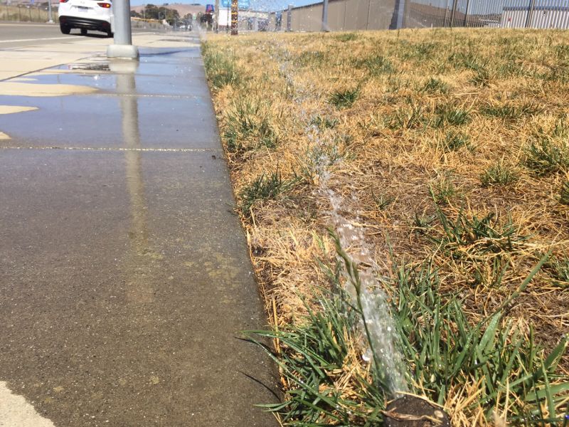
Watering that produces visible runoff (“watering the sidewalk”) is prohibited under state drought rules. (Craig Miller)
Locally the conservation mandates vary widely, from a low of 4 percent required savings, all the way up to 36 percent, and a majority of respondents didn’t seem to know what local target they’ve been trying to reach. Sixty-four percent said they did not know what precise reduction their local water district has required of them.
That bit of dissonance brought a verbal shrug from the head of the trade group for the state’s municipal water agencies, who cited high awareness among homeowners, in particular.
“You can’t bat a thousand,” says Tim Quinn, executive director of the Association of California Water Agencies. “But we’re not doing too bad, I would argue.” Quinn says he thinks the conservation message is getting through.
“We have turned a corner this summer,” he says. “People in California got it and they’re taking those actions and saving a lot of water, which is the difference between gettin’ by and not gettin’ by.”
Climate Connection
In another significant finding, nearly two-thirds of Californians made a connection between the drought — now well into its fourth year — and the changing climate. Sixty-four percent polled said that “global warming has contributed to California’s current drought.”
The operative word there may be “contributed.” While some studies have concluded that climate change was not likely the key causal factor in the drought, it’s widely acknowledged that record-high temperatures — especially last year — have worsened impacts from the dry weather.
Another lopsided majority of survey respondents — 84 percent — said they expected that global warming would lead to more droughts in the future.
In a similarly timed statewide poll by the California Water Foundation, about half the respondents rated their concern over the drought as at least 90 on a scale of 100. And a majority said they’d support monthly “water fees” of as much as $4, to support projects to help ensure an adequate water supply.